
As reported earlier, I already knew I had to ride through some snow today. What follows is the tale of how I survived the day.
Gearing Up
The route was going to be north to UT20 and over the comparably low pass to I15. Then south to Cedar City and west towards Nevada and (hopefully) less snowy conditions.
I had managed to make it this far into the SPITS run without having to:
- Put on my raingear.
- Put on my polypropylene long underwear.
- Use the heated grips or seat on the Nightowl.
Today would require all of the above, right from the start. Just going outside and to inspect the Nightowl, I was greeted with the following:
I’m sure it looked a little strange to wear Harley-Davidson raingear while piloting a BMW, but I draw the line at buying different wardrobes for my different bikes.
The Ride to the Pass
With the temperatures barely above freezing, I made my way north into the blowing snow. None of it was sticking so I wasn’t too concerned. However, with the pace of moving down the road, ice was forming on the windshield.
It was only 10 miles north to the intersection with UT20, the highway that would take me over the mountains to the west. I only made it half of that before I noticed that my right hand was getting really cold in spite of my Gerbing heated gear being on. The jacket liner and left glove were warm but not the right glove. I pulled over to check it out and the connection was good. There must be a wire either in the glove connection in the jacket liner to in the glove itself that has been contorted enough times that it can lose continuity. The gloves are pretty old and have been refurbished by Gerbing once already; perhaps it’s time for a new pair. I rerouted the wiring to the glove to bend the wire in the opposite direction and the glove came to life.
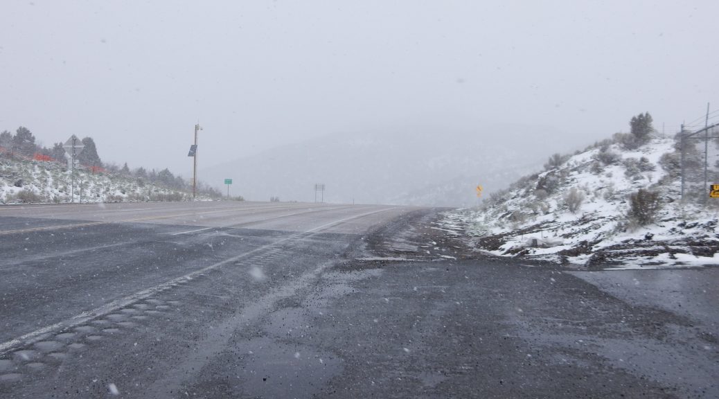
As I neared the UT20 intersection, I looked to the west hoping to evaluate conditions further up the mountain. Unfortunately, visibility had been dwindling during my ride and I couldn’t see more than half a mile to the west. Alas, I’m committed, so off we go.
The Pass
I was barely a mile west of US89 and the snow had gotten quite a bit heavier. It still wasn’t accumulating on the road, but it was starting to dust the sagebrush and pine foliage on the mountainsides. Another few miles and the ground was now pretty well covered and the bushes and trees were well coated. With the roads remaining clear, I was able to keep up a respectable pace, and on a straight stretch I relaxed enough to behold just how pretty it was.
Towards the top of the pass, the curves tightened so the pace dropped. I was not alone on this road and I pulled to the right side of the lane to allow other vehicles safe passage around me.
There was a small paved area at the top of the pass, probably to service the weather/camera station monitoring the roaf. I pulled over there to inspect the Bike and take photos.


I already knew that the windshield was gathering ice. I did not know that ice was also forming on all of my lights. The K1600 headlamp lens is glass and would probably heat up enough from the HID low beam bulb to prevent icing. However, if that same headlamp lens takes a stone hit and chips or crack, it’s over US$2,000 to replace. Consequently, vendors manufacture polycarbonate lens covers custom made for this bike to prevent such a costly disaster. The lesson learned today is that this extra layer of plastic doesn’t warm up at all and easily builds up ice. To make matters even worse, the Clearwater Krista LED driving lamps, when running at a reduced brightness for use with the low beams, also gather ice. I used my gloved hands to remove the ice and made a point to run the high beams for the rest of the pass.
As expected, the snow got heavier and accumulated more on the western slope of the pass. The airmass was being cooled as it climbed over the mountain, and it dumped it’s cargo enroute. For the first time I noticed accumulation on the road surface in the form of slush.
Fortunately, as mentioned earlier, I’m not the only one forced to use this pass, so the extra traffic has provided plenty of tire tracks to break up the slush. There were a few places where I had to stay in one tire track for a while, but the slush cleared up completely about five miles down from the pass.
I was really taking it easy through the slushy areas and about half a dozen people passed me while running dow the mountain. I noticed that they all looked at me with expressions of either amusement or pity.
South to Cedar City
UT20 ended at I15 and I turned south to head towards Cedar City. The highway was wet, but clear of accumulation and the other vehicles were motoring along at a normal pace. Even the bridges were devoid of accumulated snow.
I was doing my best to stay away from the wetter portions of the lane I was in, trying to stay in the tire tracks of other vehicles. I was also trying to stay out of the road spray from other vehicles so it wouldn’t form ice on the front of the bike like up on the pass.
The ongoing precipitation alternated between rain and snow for several miles. Then the road climbed a shallow pass at the appropriately named town Summit, where the snow returned with a vengeance and started icing up on the windshield and on my helmet. After about 10 miles of this, the road descended enough for the rain to return, melting the accumulated ice on the windshield and launching it at me in quarter-sized chunks.
As I was nearing Cedar City, I did notice one other biker going in the opposite direction. It looked like a Star or Indian bagger; it was difficult to tell for sure with the reduced visibility. Needless to say, we didn’t wave at each other.
I was trying to remember which exit to take at Cedar City (there’s three). I wanted to pick up the route Yo Adrian and I used in the opposite direction coming home from the SNIFF party back in 2013. I had the Waze navigation app programmed to route me to Tonopah, NV, but it had lost its mind in the mountains and now insisted on routing me down to Las Vegas to get to Tonopah. Consequently, it was no help whatsoever in finding the correct exit. The second exit for Cedar City advertised UT56; that sounded like a familiar highway, so I turned the handlebars towards the off ramp.
I filled up with gas in Cedar City and took a moment to verify that I’d picked the correct exit. Yes, UT56 went west to the Nevada border and hooked up with US93 near Panaca, where I could turn south for Calliente. That’s definitely the same route.
I also checked weather radar, hoping to find a clear scope west of Cedar City.
Dream on, loser.
There was more rain and snow to the west but it should be over before I hit the Nevada state line.
One Last Snowy Pass
I forgot there was another low mountain pass west of Cedar City. During this climb, the rain turned to snow again and persisted well down the west slope. In a rancher’s field, I saw a herd of cattle huddled together around a single tree. Safety in numbers; what a luxury.
Suddenly the snow stopped. It didn’t turn into rain and then stop. It didn’t slowly wind down and stop. It just stopped. With the sudden increase in visibility, I could clearly see the end of the clouds and the start of sunshine and blue skies on the next range of mountains to the west. Needless to say, this was a tantalizing sight.
The Ride Becomes Pleasant
About fifteen minutes later, I’m riding in full sunshine between broken clouds with the temperature increasing above 50ºF. It was as if I time warped to a completely different day. I was able to relax a bit and dial back a few notches on the heated gear.
Upon finding a new cell tower (we’d been running out-of-service for quite a while), the Waze app finally found a clue, and figured out how I’m trying to get to Tonopah. This was fortunate timing, since I knew I had to turn south somewhere up ahead and I couldn’t remember where that was.
As it turned out, I wouldn’t have missed it.
NV319, which is what UT56 turned into at the state line, ends at US93 in Panaca. I noticed that Panaca (and Caliente a few miles further down the road) both have a 25mph in-town speed limit. Isn’t that a bit extreme? I think I got passed by a kid on a skateboard. I turned south on US93 towards Caliente, pondering the trade offs between citizen safety and reasonable vehicle speeds.
I had planned to get gas in Caliente… and I followed my plan. It should be noted to any bikers traveling this route that the region between Caliente and Tonopah is devoid of gas stations. If you’re not completely confident that you can get at least 195 miles on a tank of gas, then you need to know about the secret life-saving gas station about six miles south of the US95/NV318 intersection in the thriving berg of Ash Springs.
On either the Cruiser or the Vector, I could make it from Tonopah to Ash Springs, but not all the way to Caliente. With the Nightowl, I should be able to reach Tonopah directly without the side trip to Ash Springs. I should reach Tonopah with ~50 miles to spare.
The Extraterrestrial Highway
When you turn off US93 onto NV318, you’re only on it for about half a mile. Then you turn left onto NV375, otherwise known as the Extrateresseral Highway. The name stems from the high number of reports of strange things flying around in the sky, probably experimental aircraft being tested at that worst-kept-military-secret: Area 51.
I didn’t see any strange things in the sky, but I can say this: This is one lonely stretch of road. Like many of the roads that cross Nevada, the ET Highway follows this pattern: mountain pass, desert plain, repeat. If you can appreciate the stark beauty in this brand of desolation, you’ll love this highway.
After the first 20 miles or so, the stretches of desert plain were getting larger and the winds in these unprotected flats were getting stronger. I already knew from reading the forecast for Tonopah that high winds were a possibility on this day. Now the weather was starting to live up to it’s billing.
Not to go into too-much-information territory, but I really had to pee big-time as I neared Rachel. Not really wanting to stop at the Al-ee-Inn Cafe (get it?) just to visit the restroom, I chose to stop at the last dirt road heading south before you reach town. (Rachel is pretty small, so town is probably a bit gracious.) As I stood by the road to irrigate the base of the stop sign, I noticed the multitude of decals applied to the face of that sign. That’s when it hit me: this is the road to the Groom Lake dry lake bed that is home to the aforementioned Area 51.
Cool!
This demanded few photos.


Continuing down the ET Highway, I became acutely aware that the stiffening wind was really killing my gas mileage. I kept a vigilant watch on the miles-to-empty gauge to make sure it’s value remained greater than the remaining distance to Tonopah. Better yet, I switched the display to show the current gas consumption so I coils monitor it. If I have to, I’ll slow down to reduce consumption and maintain the required range.
Object Lesson Time (but not for me)
The ET Highway ends at US6, which continues southwest to Tonopah. This location is noted as the town of Warm Springs on several maps, but they all are lying bastards. The only thing in Warm Springs, NV is a old shut-down cafe. There’s not even a street lamp or a pay phone (or cell service).
As I turned south, I noticed a van and a motorcyle by the side of the road with the biker dismounted and talking to the van driver. Wondering if someone broke down, I pulled over to see if everything is alright.
It is decidedly not alright.
Not one but both of these separate travelers ran out of gas. The guy in the van expected there to be a town here; poor bastard. The biker filled up in Caliente and figured he had enough to reach Tonopah… until he hit those nasty headwinds and ended up running out 49 miles short.
They informed me that they already had two different guys who volunteered to help, so rather the complicate search-and-rescue efforts further, I chatted with them a while and got on my way.
That is an especially bad place to run out of gas. There’s literally nothing out there for 50 miles in either direction.
Hellish Crosswinds
From the Tonopah weather forecast (I mentioned it earlier), I knew that the wind was going to get worse the closer I got to Tonopah. I did not, however, expect the insidious combination of recent chipseal and nasty crosswinds.
The construction zone with the recent chipseal introduced itself as a 27-mile-long construction zone. It was a bit like seeing a sign saying: Road under construction for the rest of your bloody life. It was impossible to tell just how old the new chipseal was. When it’s freshly laid, it can be rather treacherous for motorcycles. As it gets driven upon, it firms up a bit, but can still be loose in the middle and between lanes.
With the increasingly strong and chaotic crosswinds, it became nearly impossible to keep the Nightowl within a single tire track in the southbound lane. When the wind blew strong enough to push me into the unsettled areas of chipseal, it was (needless to say) a significant sphincter pucker factor and a major squeeze on the adrenals. This was much worse than the snow from the start of the day.
By the time the construction zone stopped in the outskirts of Tonopah, I had been (I’m embarrassed to say) blown into the oncoming lane twice.
Very bad.
Lucky for me, the road was nearly deserted.
Gas and Room
I gassed up in Tonopah before I started the search for a room. I originally had aspirations to continue west to Hawthorne for the night so I would have a really short travel day on Thursday. However, after that harrowing experience with the crosswinds, and knowing that the winds were forecast to be lighter (or at least not as murderous) tomorrow, it was an easy decision to call it a day.
The biggest motel in Tonopah is the Tonopah Station Casino. It’s also the biggest tourist trap in town. This downside is countered by the fact that it is clean, reasonably priced, and has a decent restaurant, which means you can park your bike and not have to wander off in search of food.
What’s Next?
Tomorrow I should reach the ultimate destination for this trip: the SPITS party near Valley Springs, CA. I’d like to take Tioga Pass over the Sierra Nevada mountains, but it is still closed for the winter. That probably means a more northerly route with a trip through Carson Pass instead.