
Today I hoped to have an easy ride to the end of my westward journey and arrive at the party location for Redbeard’s memorial gathering. All that stood in my way was South Lake Tahoe lunch establishments, the Sierra Nevada mountains, and an oncoming heat wave.
Before the ride
Once again, I woke up before my alarm went off. I’d almost fallen asleep at the keyboard last night while composing the previous day’s ride report, so I had some work to do to finish it.
First, I grabbed a quick shower and then walked down to the Nightowl to extract the memory card from the INNOVV K5 dash cam unit so I could assemble some video from the previous day.
Back in the room, I tried to upload yesterday’s photos, only to find that the hotel’s WiFi was so heavily favoring downloads instead of uploads, that virtually nothing was getting through.
Argh.
After repeatedly attempting to upload each photo one at a time, I finally got them all uploaded. What a slog. I knew that, if I had this much trouble with still photos, there was no way I’d ever get several minutes of 4K video to push through this connection. I’d have to upload that later.
By the time I got everything staged and ready to publish once the video was uploaded, it was nearing checkout time. I had to get my ass on the road.
The ride to Lake Tahoe
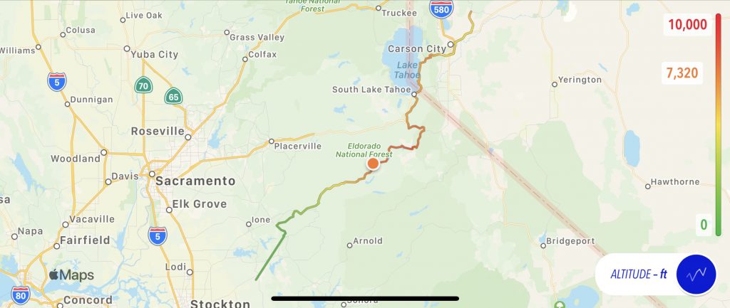
Outdoors, it was another stunning day in paradise. Blue skies and comfortable temperatures… but that was here in Virginia City, waaay up a mountain from my path west on US50 down on the desert floor.
I rode down the curvy road down the mountain and each passing mile came with an increase in temperature. By the time I turned west on US50 towards Carson City, Nevada, it was in the upper 80s F (low 30s C).
In Carson City, the Waze app wanted me to ride south on US395 to CA88, which was the highway I’d use to cross the Sierra Nevada mountains via Kit Carson pass. Unfortunately, that bypassed the US50 route along the south side of Lake Tahoe. Waze was doing this to provide a quicker route, because the Lake Tahoe area was notoriously congested. I, however, didn’t give a shit about that. I found the Lake Tahoe shoreline very scenic and I was bound and determined to eat lunch while gazing out at the mountains surrounding the bright blue waters of Lake Tahoe.
The heart has its reasons which reason knows nothing of…
Blaise Pascal
Before I can have my scenic lunch, I have to cross the mountains to Lake Tahoe. Luckily, most of the route from Carson City, Nevada to South Lake Tahoe, California is four lanes, so passing the slower traffic up the mountain was fairly easy.
Aside: Lake Tahoe is a lake, not a city or town. The main city at the south end of Lake Tahoe is South Lake Tahoe.
The downward ride into South Lake Tahoe is a long four-lane stretch of curvy shoreline road, most of it posted for a 45 MPH speed limit. Naturally, everybody drives this stretch at 70 MPH. With all the intersections with traffic entering and exiting US50, and all the tourists primed to stop at a moment’s notice for a photo opportunity or a parking spot, you need to be on our toes.
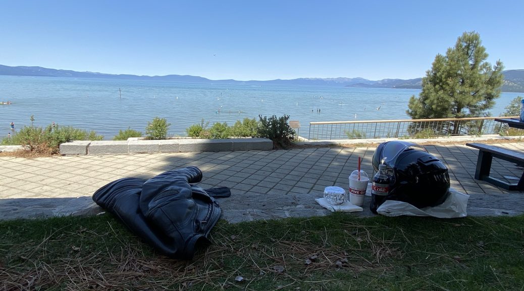
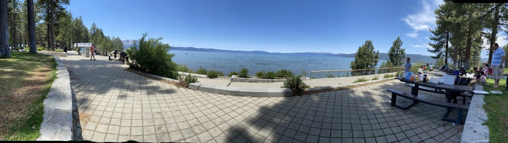
It was right about straight-up noon, so pretty much everybody and their brother were out searching for lunch… just like me. My hope was to find a sandwich/sub shop that I could quickly obtain food to-go, and then ride on to the main roadside park at the Lake Tahoe shoreline. There I’d park the Bike, find a shady spot, and eat my lunch with a gorgeous view of Lake Tahoe.
Not knowing where anything was, I stopped at a gas station and checked the Yelp app for sandwich venues. There was a Subway sub shop nearby, so I bought a bottle of pop for lunch and headed over to Subway. When I arrived, the line of customers stretched across the inside of the shop and out into the parking lot.
Ugh.
I searched for other options. There was a deli two blocks away, so I rode over and found a parking spot. Walking into the “deli”, I didn’t find a sandwich counter, but rather a full bar and tables for sit-down eating. The woman in line in front of my had a similar idea and was ordering some sandwiches for take-out. She asked about her wait time for the two sandwiches and I heard the waitress say, “20 minutes”.
Ugh.
Back out in the parking lot, I saw a sign for a Five Guys burger place one block away. A burger wasn’t really what I had in mind, but I’d already wasted too much time on this obsession for a picnic lunch, so I rode over and walked in.
To my amazement, there was no line of customers to wait through. I ordered a burger, a strawberry shake, and they had them both ready in about five minutes. So, with my plastic bag of burger, shake, and soda, hanging off my right-side mirror, I rode the last couple of miles to the park.
I was able to find a shaded parking spot on the street (the park’s lot was full) about a block away from the park. The park itself was busy with other visitors, but there was still plenty of shady space for me to have a seat. Finally, after almost an extra hour of screwing around trying to make it happen, I sat down for my lunch overlooking Lake Tahoe.
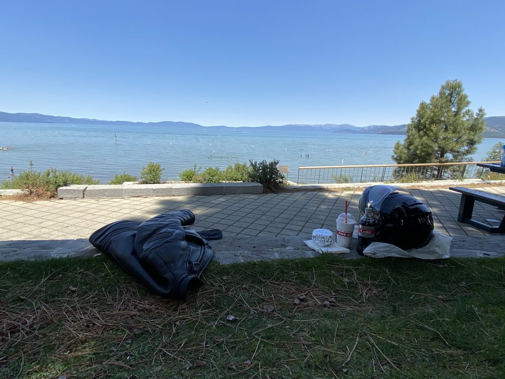
The burger was tasty and the shake refreshing after my protracted search for sustenance. I’m glad the heat wasn’t as bad near the lake or I may have simply gotten too frustrated and given up. I thought it was worth it.
With lunch out of the way, finally, it was time to finish this ride.
The ride to the party location
To get to the party location, I needed to jog south on California route 89 and then west on California route 88 through Kit Carson pass. I’d taken this route before and, now that I was in a bit of a hurry, decided that I wouldn’t be stopping for many photos. (For photos of Carson pass from earlier trips, check this post and scroll down to the Last Dash Through Carson Pass section.)
I’d just turned onto CA89 south when I received a text message from my host for the next few days. He was letting me know that he was heading out to run some pre-party errands would be back around 3pm. If I arrived before he was back, I should make myself at home.
This was very cordial (what an I say? I have very cool friends) but I wanted to let him know that I wouldn’t be there until around 4pm.
Since I was riding, I couldn’t type in a response. I often use Siri voice recognition on my iPhone to dictate text message replies in a hands-free fashion. Frankly, I’ve gotten quite good at it. As long as the connection to the Apple servers is good, the translation is usually quite accurate and fairly quick. If, however, you’re moving in and out of reception as your path weaves between mountains, things aren’t quite as accurate.
Ghost: Send text to Fins.
Siri: What would you like to say?
Ghost: I just left Lake Tahoe and won’t arrive until after 3pm… wait, no, no, no…. I meant 4… Shit.
Siri: Your reply to Fins says: I justify Ivanhoe and want arrive until after 3 beam wait no no no I meant for shit.
I retried the message three times and each time the interpreted text was wrong in a different way. By the time I tried a fourth time, I was on the wrong side of the mountains and no longer had service.
I wanted to arrive at the party location in time to join the other early arrivals for a dinner out, so I was moving along with purpose. Given the length (so far) of this journey, it seemed strange that I hadn’t seen many police cruisers out on patrol and only a few sitting in speed traps. Therefore it was a bit of a surprise when I found myself looking at an oncoming California Highway Patrol Cruiser heading towards me when I was slightly bending the posted speed limit.
“That’s it,” I’m thinking, “I’m nailed.”
To my amazement, the patrolman flashed his brights at me and motioned with one hand to slow down. I waved back, rolled off the throttle and started counting my lucky stars that I found a sympathetic law enforcement officer.
The summit of Kit Carson pass isn’t too far west of the CA89 / CA88 intersection. From there, it’s about 60 miles (96 km) of a curvy downhill ride to CA49 in the foothills. I generally find this ride very scenic and enjoyable, as long as you don’t get stuck behind someone who molests your pace.
I did end up behind a few obstacles on this ride down from Carson pass. Some were cars and trucks that I eventually found a way to pass.
The other was a construction zone from hell.
First, there was a warning sign for Loose Gravel, which usually means a fresh coat of chip seal on the road, which can make motorcycles a bit unstable, especially on a curvy road like this one. The roadway here looked like fresh asphalt, so a final coat of chip seal would be expected. I rode on expecting to see the fresh black asphalt give way to fresh grey chip seal, but that didn’t happen. Instead, traffic came to a halt behind a construction truck that was rolling down the highway at the pace of an 80 year old woman using a walker.
For a car, the slow pace isn’t a big deal. You leave the transmission in Drive and use the brake to control your speed. For a bike, with a clutch and manual transmission, you have to constantly feather the throttle and clutch to maintain this speed, which was actually lower than the speed of being in first gear at idle. To make matters worse, the temperatures had been rising as the highway descended the mountain and stopping in the direct sunlight was a bit like cranking up a sauna to broil. To maintain a modicum of comfort, I was carefully choosing my stopping points to be in the shade of the roadside trees. Once, I couldn’t avoid the direct sunlight, and eventually pulled off into a roadside parking lot for a gift shop because there was shade there. The driver in line behind me must be another biker (or a generally tolerant soul) because he seemed to understand what I was doing and let me back in when traffic finally started moving down the road again.
When I finally passed the construction vehicle (it it pulled onto a turnoff), it turned out to be a road stripe painting vehicle. Our slow pace was the speed he was painting the lines on the new road surface.
With the slug’s pace construction zone behind me, I was finally able to make some time down the mountain. It was a fun ride, but increasingly hot. When I finally turned off CA88 to southbound CA49, it was 104º F (40º C).
I’d joined CA49 in the town of Jackson, and there were a few stoplights to get passed before I could continue south to Mokelumne Hill, where I would turn southwest. Usually, when traveling between stoplights in town, you’re moving slow enough that you can open the face shield on a full-face motorcycle helmet and cool your face a bit. With this heat, that didn’t work. If you’re face inside the helmet was like an oven set to Bake, your face with the hot ambient air blowing on it was like an oven set to Convection Bake. This was as bad, or worse, than the heat I’d experienced back in Green River, Utah.
It would get worse.
A few miles down the road, CA49 enters a sequence of 758 low speed curves while it ascends Mokelumne Hill. During this stretch, the line of cars I was buried within was cumulatively stuck behind a driver piloting their economy sedan like they were maneuvering the Queen Mary. With all the time I had idling along behind our slowpoke, I considered the nature of the universe, read the collective works of Shakespeare, and developed a new theory for the mathematics concerning quantum foam.
Oh, I also had time to check the ambient temperature, which now read 110º F (43º C).
I finally reached my next turn and gleefully left the line of frustrated drivers behind the slowpoke, turning southwest towards Valley Springs.
I stopped to top off with gas in Valley Springs and also to clean my windshield, which had suffered an insect impact that must have been the size of a B52 super fortress bomber. With my sight down the road restored, I navigated the final miles until I parked in front of my host’s house.
Aside: The first time I rode to this location from my home in Michigan, I traveled 2,687 miles (4,324 km). This time, I took a very different route between the same start and end locations. The total mileage this time?
2,691 miles (4,330 km).
Only four miles (6 km) difference. That blows my mind.
The evening
Friends were greeted. Hugs were exchanged. Hydration was achieved. Cool adult beverages were consumed. Dinner was eaten (and enjoyed).
Some finished the evening talking under canopies in the relative cool of the evening. Your author sat down at the host’s bar and wrote this report.
Map
Due to the high temperatures on the west side of the Sierra Nevada range, the iPhone overheated again, so there’s a gap in the map data, but you can get the basic idea.
Video
A few selected passages from the day’s ride.
Tomorrow
I won’t be traveling tomorrow (or the day after that) since I’ll basically be hanging out at the party location and spending time with friends. Consequently, there will be no trip report in a traditional sense. As a tribute to my late, great friend Redbeard, I may post a Redbeard story or two.