
Today we started in the deep freeze, imitated border collies, added two members to our happy little band, and crossed a desert.
The Start
We start where we left off, Panguitch, Utah. The biggest difference between last night and this morning was the weather. Not the sunny cloudless skies, no, that was the same.
It was the temperature.
When we started packing the bikes, it was a crisp, clear 27ºF (-3ºC) with a windchill down to 18ºF (-8ºC). Given these conditions, our plan (naturally) was to ride our bikes at highway speeds and climb a 10,000 ft mountain, where it would definitely be colder.
Yes, we’re idiots.
After grabbing a bite of breakfast from the hotel, we donned as many layers of insulating gear as possible (Gerbing’s, there is no substitute), and stopped at a gas station to top off. When we left the gas station, we had to wait for a pickup and horse trailer to get out of the way. We knew these people were working ranchers: they both had actual spurs on their boots and their horses in the trailer were already saddled. We followed them out of town, headed south on Utah Highway 143.
The timing of this day was important. Tud and Ange were flying into Las Vegas and due to arrive at 1pm local time. They were renting a Bike and would join us for the rest of the day’s ride into California. Not wanting to make them wait, we needed to arrive in Vegas on time.
The Ride to Cedar City
Almost before we left the city limits of Panguitch, UT 143 started to climb. It would continue to climb for another 23 miles. I had my electric gear cranked up pretty high: high enough that I didn’t get hypothermia, but not so high that the neck heating elements charred my flesh. It was a delicate balance.
About the time we reached Panguitch Lake, we were halted by an unusual sight. There was a single walking man in a cowboy hat, accompanied by four dogs, herding several hundred sheep down the highway. There was already one car in front of us waiting for the sheep herd to get wherever they were going. The cowboy ignored the car. The sheep slowly made their way down the road, furiously munching on the virgin ungrazed flora on the road’s shoulders as they passed. Every now and then they would meander too far from the road and the cowboy would give the dogs a command and they would hustle to the trouble spot and get the sheep in line. To be honest, it was fairly impressive.
After a few minutes, the cowboy came over to me and told me to just pass the car, ride just fast enough to enter the herd, and the sheep would get out of our way to allow us to pass.
Cool, we get to be border collies.
We passed the car on his left and ventured into the herd. Sure enough, the sheep parted like the Red Sea (the Wool Sea?) and made space for us to roll through. The guy in the car didn’t get the hint and laid back. He may still be back there.
Within a few seconds of us escaping the sheep herd we encountered a second, albeit smaller, sheep herd making is way down the road towards us. This one was escorted by a second cowboy, this time on horseback, with his own contingent of herd dogs. Following the lead from our first herd, we slowed down, and made our way through. The sheep, once again, obliged and made a path for us.
Aside from the chance to be a border collie, the best part of this delay was a chance for our electric gear to catch up with the conditions and warm us up a bit.
We continued to climb the mountain, eventually reaching the end of UT143 where it t-bones UT148. It was here that we reached the reason for venturing to high elevations on an already cold day: Cedar Breaks National Monument.
Think of Cedar Breaks as a miniature Bryce Canyon. A rounded edge of a mountain top eroded away to expose vibrant colored rock formations in unusual shapes. Pete had been here before. I’d only seen pictures. (I’d tried to visit Cedar Breaks during my journey to the 2017 edition of SPITS but the road was closed due to snow.)
We parked at an overlook, marked with an altitude sign of over 10,000 feet. The wind, which had been mostly absent during our ascent, now rolled over the edge of the cliff like a banshee. We hadn’t walked half of the 50 yards from the parking lot to the overlook when Pete lamented the fact that he left his gloves back on the bike. According to the Nightowl’s temperature gauge, it was 18ºF before the windchill. I’m not sure I want to know just how cold it really was. On a side note: heated gear does a great job while you’re going down the road; not so much when it’s unplugged and you’re walking around.


The Ride to Las Vegas
Back on the interstate, there’s not as much to say. We rode. The miles rolled. We stopped for gas in St. George and Ghost found a penny in the parking lot. Good luck all day (we hope).
All the way south to Vegas, it got progressively warmer. By the time we entered the valley that houses Las Vegas, it was in the low 60ºF range. We got a kick out of the palm trees planted at some of the interchanges. We also saw several jet fighters take off and disappear to the west.
By the time we got a few blocks from Tud and Ange’s motorcycle rental agent, it was a little after 1pm local time. As I entered my gas fillup data on my iPhone, I saw a text message from Tud announcing that they had landed and were waiting for luggage. Tud and Ange said they didn’t need lunch, but we did, so we found a Famous Dave’s and gobbled down some BBQ while Tud and Ange made their way through customs and to the rental agent. It didn’t take long; we were halfway through our meal when Tud announced that they were at the agency.
We arrived at the agency and greeted Tud and Ange as they waited for their bike: a nice newish black ElectraGlide. They transferred their belongings to the rent-a-bagger while I sought motel reservations for the evening in Lone Pine. For some reason, rooms were scarce and I reserved the last two rooms at the Mt. Whitney Motel. Packed and ready to go, we departed Las Vegas westbound on Nevada Highway 160.
The Ride to Lone Pine
Given that most of it is four-lane divided (but not limited access), I expected the ride to Pahrump to pass quickly. It would have weren’t it for the long one-lane construction zone for the entire pass west of Las Vegas. To make matters worse, the construction vehicles (big tandem dump trailers) were also using the road, crawling up the mountain in second gear while hundreds of vehicles idle along behind them.
Arrrgh!
After that pleasant (not) experience, we finished the ride to Pahrump unscathed. I’d originally planned a gas stop for Pete in Pahrump, but the remaining distance to our target of Lone Pine would have required yet another gas stop. So, I hoped that we could obtain fuel either at Death Valley Junction or in the park itself. There was no gas at Death Valley Junction, so the park became our only hope.
There was no need for gas angst since both of the visitor centers at Death Valley National Park had gas stations. Oh, but the prices! But I get ahead of myself.
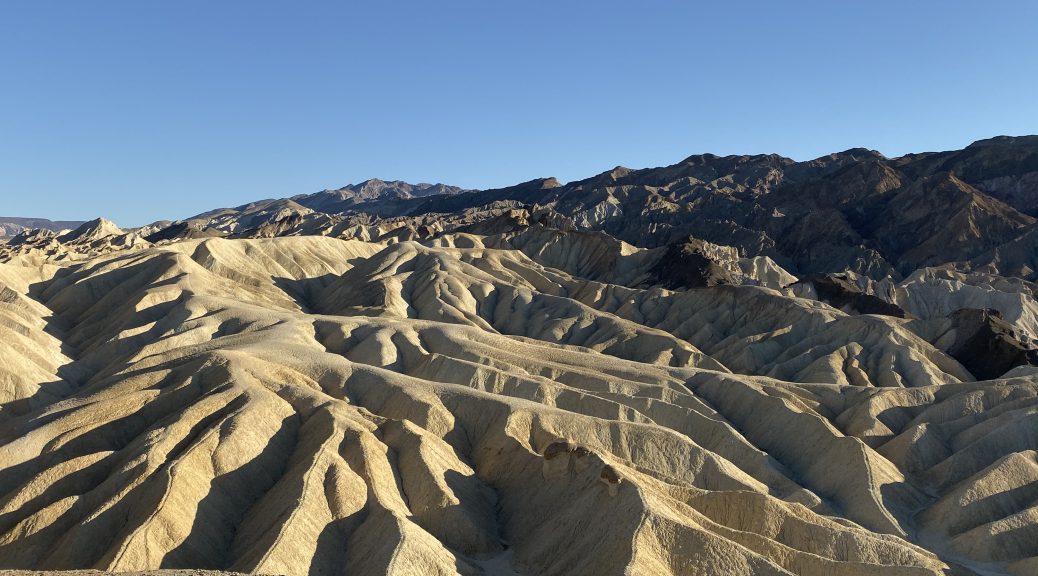
We rode into the park in the late afternoon, the lowering sun casting dramatic shadows on the rock formations that lines the road. We stopped at the Zabriskie Point overlook, taking the short but sometimes steep hike to the viewing area. We unanimously agreed that the view was worth the effort.


We reached the Furnace Creek visitors center before anybody ran out of gas. I knew the Nightowl would make it all the way to Lone Pine, so I didn’t pull up to a pump. The prices posted on the sign at the gas station made me very glad for this: $5.609/gallon. Mother Mary! I asked Tud, who had lined up at a pump, what is remaining mileage gauge said, he said 160 miles. I said, “Don’t bother”. Pete, unfortunately, had no choice, though he elected to inject only $10 worth of the very pricey fuel; enough to get him to the night’s destination.
The sun set over the distant mountain pass to the west when we still had ~60 miles to traverse. Climbing the first of two last passes, we were in complete shadow and the temperature steadily dropped into the upper 50ºs (F).
During a long straight stretch along a valley floor, we were passed by a Maserati sports car. When we reached the end of the valley and approached the climb up the next pass, the Maserati driver balked at passing the last car and Class C RV. Not wanting to climb the upcoming pass at an RVs pace, I gave Mr. Maserati a quick honk and we all passed him back, along with the car and the RV. I guess Mr. Maserati’s balls were only big enough to allow passes on 6-mile straight-and-level stretches of roads.
Mr. Maserati would eventually catch us during our descent down the other side of this pass, stuck behind another slow poke. He would alternate between following at a respectable distance and sucking on Pete’s exhaust pipe. He turned off to stay on CA190 when we ventured forth on CA136.
We reached Lone Pine with Tud’s bike running on fumes. Apparently, a 160-mile fuel remaining reading really means 106 actual miles remaining.
After the Ride
We checked in our hotel, at which time we discovered why the rooms in town were scarce and rates higher then estimated. There’s a film festival in Lone Pine this weekend.
Hurray.
Still, even with the relatively expensive rooms, we counted ourselves luckier than the poor bastard in the Corvette that arrive the same time as us and was turned away to find other lodgings. I imagine he finally found accommodations in a farmer’s barn.
We unpacked and headed down the main drag in search of the two primary requirements:
- Food
- Full bar
We found both at the Seasons restaurant. Adult beverages were consumed, dinners were devoured, stories were exchanged, and lots of laughter was shared.
Back at the motel, Tud and Ange noted that they had been up from 5am their local time to 1am their local time. Time for sleep.
Map
For the second time the trip, my Trails app failed me and stopped recording shortly after we entered Death Valley National Park. Very obnoxious. Instead, I offer the map from my Where’s Ghost tracker page.

Tomorrow
We ride up to Sonora Pass and on to the party. Almost there!