
After postponing my Lolo Pass crossing by one day, I finally get over the pass and wander across southeastern Washington state.
Pre Ride
The alarm went off at 8:30am. I woke up fairly well rested. A quick look outside revealed no rain at the moment, but plenty of puddles here and there, speaking to the all-night showers we had.
I indulge in a shower and pack up. There’s leftover pizza from the small=large mistake from Pizza Hut last night, and I do have a microwave in the room, but I’m not really hungry.
I check a few things online, reply to a few messages, and suit up for the day’s ride.
I had to postpone my Lolo Pass ride one day because yesterday’s weather over the pass would have been absolutely unlovable. That ride would have involved no joy whatsoever. At least today I would have a chance to have some fun. After that… I wasn’t sure. I knew I’d stay on US12 down the Clearwater River valley all the way to the Idaho/Washington border at Lewiston, but I had no established plan after that.
The ride over Lolo Pass
Lolo, Montana is only 10 miles south of Missoula, so it didn’t take me long to get there. I did make one stop just before turning onto US12 west at Lolo; I needed to clean off my windshield to get rid of the rain spots that accumulated from the overnight deluge.
Lolo Pass is a fun ride, but not for the reason that you might think. The pass itself isn’t over spectacularly craggy mountain peaks. The surrounding scenery isn’t overly astounding, just endless pine forest. The pass isn’t that high either, only 5,235 feet.
Why, then, do so many motorcyclists suggest Lolo Pass?
It’s the creeks they follow.
What?
The road up the east slope of Lolo pass follows the Lolo creek. The road on the west slope follows the Lochsa river, eventually converging with the Clearwater River. These facts, by themselves don’t tell the entire story. The fun part is that US12 follows these water grades with a commitment that humbles couples married for 50+ years. The road never leaves the north bank of these creeks/rivers and almost never looses sight of it.
Traveling east to west, my favored traversal of Lolo Pass, the ascent takes a little less than 30 miles. It’s fun, but not the main event. The descent down the west slope follows the Lochsa River for almost 100 miles, and I assure you that the path of the river is not straight.
Most people who have heard of, but not ridden, Lolo Pass, know it because of the “Curvy road next 99 miles” sign just west of the summit. There are other impressively numbered signs.
“Watch for rock in road… next 60 miles.”
“Game crossing… next 40 miles.”
You’re beginning to get the picture, yes?
The western slope is isn’t overly tight; mostly 30-45 MPH curves near the top and then broadening a little to top-gear curves about 1/3rd of the way down. The road engineers have done us a favor by being generous with passing opportunities. There are even wide open curves with good sight lines along the river where you can pass several cars. If you’ve been wanting to practice mid-speed Sweeper entrances and exits, then Lolo Pass is your road. It was truly created to train the faithful.
I absolutely love it.
Authors note: One word of warning. Don’t do Lolo Pass westbound late in the day or eastbound early in the day. The problem is that the river valley is deep and the low angle of the sunlight in those conditions will cast hard shadows along the corners and force you to constantly travel between glare and shadow. Not a fun combination when you’re attempting a spirited ride. I made this mistake the first time I rode Lolo and vowed to never make it again. (On a cloudy day, do whatever you want; it won’t matter.)
For this day’s ride, the roads were a little damp, especially near the summit, but otherwise passable. I’m was a little leery of the damp roads because I’m running Michelin Pilot 4 tires this trip instead of the Metzeler Roadtec 01 SEs that stick in wet conditions really well. Luckily, the roads were never wet enough to get more than a tiny bit unstable under the Pilot 4s.
The chill of the day meant that there was a little fog over the river and puffs of mist clinging to the mountainsides, a bit reminiscent of the hills along US23 in eastern Kentucky in similar conditions. The riverbed on the western slope is unendingly rocky, with some boulders of impressive size. I’ve heard that the spring runoff down the Lochsa is a site to behold.
Another feature of the day (so far) was the lack of smoke. There had been a significant wildfire just a stone’s throw away from US12 along Lolo Pass but I saw no evidence of that besides the quiet fire camp just west of the summit.
The traffic was fairly light (it’s Wednesday morning) and I was able keep up a fun pace and easily pass the few vehicles that didn’t want to have as much fun as I. There was only region of single-lane road that delayed me for about three minutes; no big deal.
It was a great ride.
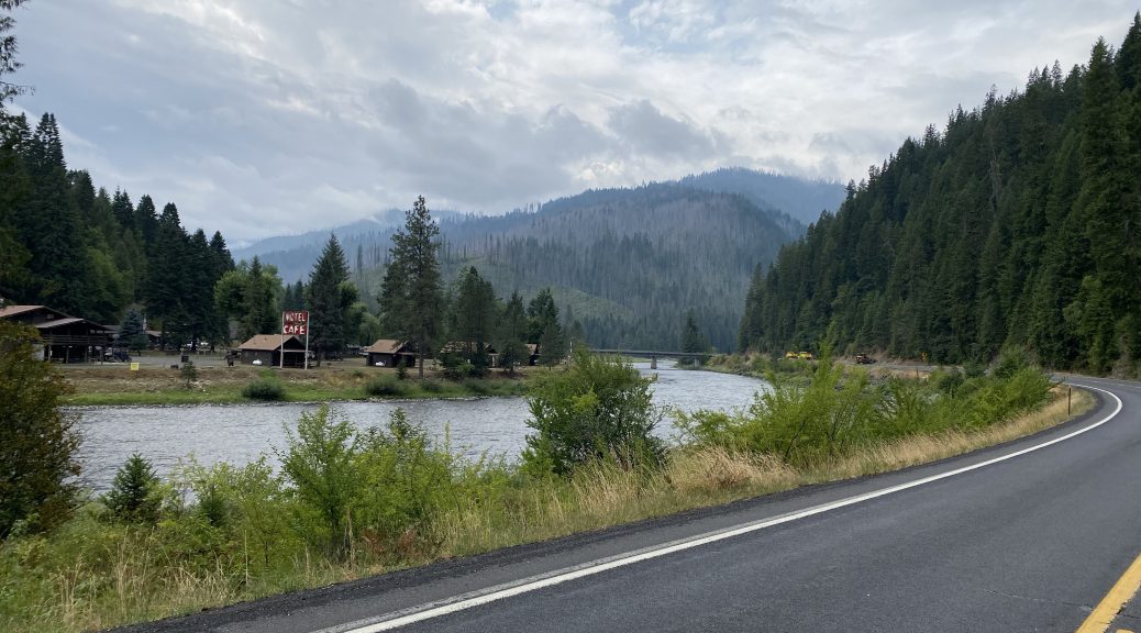
Lolo Pass officially ends at Kooksia, Idaho, but the river-following fun doesn’t stop there. The Lochsa River has joined with the Clearwater River and US12 continues to follow the Clearwater all the way to Lewiston, another 60 miles away.
I stopped for lunch at a little Mexican restaurant in Kamiah, Idaho. The cube steak and molé burrito was quite good.
The rest of the ride to Lewiston was warmer and sunnier. I’d ditched my heated gear after lunch and was now wearing the perf gloves and nothing under my jacket but a t-shirt; I was comfortable.
The Ride to Lyons Ferry
I needed gas at the border, but waited until I crossed into Washington. Was that smart? I don’t know the average gas prices from state to state; I should have looked that up ahead of time; there’s an app for that. After fueling up and sucking down a Vitamin Water, I decided to pay a visit to a nice crossing site for the Snake River: Lyons Ferry.
That meant continuing west on US12 for 50 miles before turning right on WA261. Shortly after passing the thriving metropolis of Starbuck, you descend to the Snake River riverbank in a wide canyon. Ahead of you is a long high steel bridge over the river. Past the auto bridge, connecting high up at the top of the canyon wall, is a very tall railroad bridge. These bridge cross at very different angles and (as mentioned) at very different heights. It’s an impressive site, and it’s in the middle of nowhere.
On the west (north) side of the river is Lyons Ferry State Park, which consists of a picnic area and a boat launch. I stopped there anyway because it gave me an opportunity to grab a photo or two.


From here I decided that I could make Yakima pretty easily. I could get there using US395 and I82, but (as usual) what fun is that. I know a good backroad route through here, so I’m going to do that. There’s a state park just outside Yakima that looks like it has available tent sites. The weather will be cool tonight; it would be nice to camp, even if the burn ban prevents me from having a fire.
The Ride to Yakima
The rest of WA261 west to WA260 is fully of interesting twists and turns through plenty of elevation changes. In short: it’s a good motorcycle road, even without the breathtaking scenery along the Snake River. Add it to your to-do list if you’re in the area.
The rest of the ride to Yakima is something I’ve done before; traversing the southeastern Washington desert. Some of it is visually interesting, but not what most people consider scenic. That means it’s time to turn on the music.
I’m often amused how my circulating but randomized playlist does a surprisingly good job at being topical for whatever conditions I’m riding in. Sure, a lot of that is in the ear of the beholder, but some of the synergy is interesting enough to share.
For example, traversing a wide brown-grass valley towards the barely visible mountains at the horizon, Warren Zevon starts playing:
Send lawyers, guns and money,
Lawyers, Guns, and Money
To get me out of this.
Warren Zevon
Then, between Connell and the turn at WA17, through apple orchards and not another car in sight, Cheryl Crow sings:
Like Steve McQueen,
All I need’s a fast machine,
And I’m going to make it all right.Like Steve McQueen,
Steve McQueen
Underneath the radar screen,
You’ll never catch me tonight.
Cheryl Crow
Later on, while skirting the edge of the Hanford Nuclear Energy Site, looking at the test nuclear plants in the distance, the opening strains of She Sells Sanctuary starts playing. Knowing that the wake-up drumbeat is coming to signal the start of that infectious main riff, I cancel the cruise control and get ready to nail it.
The fire in your eyes,
She Sells Sanctuary
Keeps me alive.
The Cure
Now I’m in the hops and corn fields west of Yakima. It’s been a cooler day than usual here and the sun is getting low in the sky, so nearly every farmer and orchard owner has their sprinklers running. Even though it’s not that hot, I can still feel the change in humidity when I pass the wet crops.
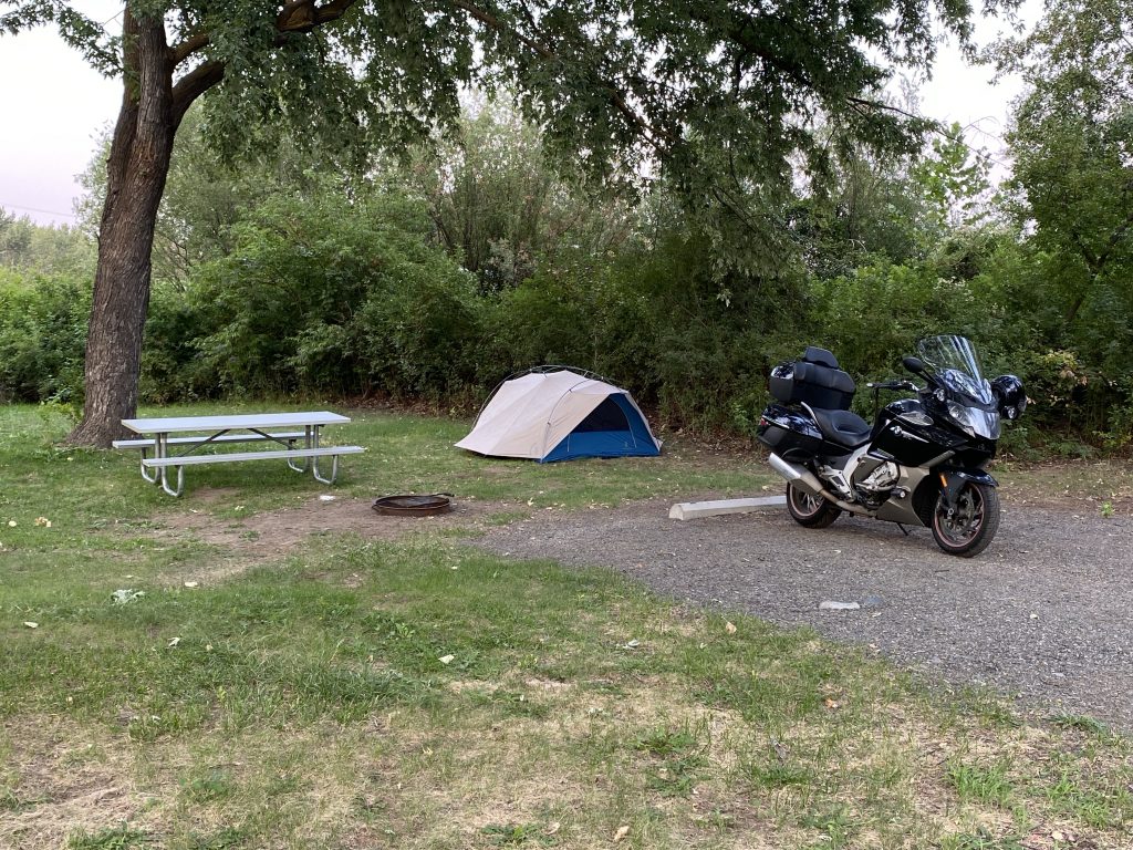
I arrive at the outskirts of Yakima and see a sign for the Yakima Sportsmen’s State Park. I know it’s only a mile or two away, so I decide to check it out before going into town.
It is a nice little park with lots of picnicking space and a quaint little campground. $32 for one night in a tent site with no electricity (for charging stuff) isn’t exactly cheap, but it’s better than spending two- to three-times that for another hotel room.
I pull out my phone and open PocketUniverse. I can use this app to find things in the night sky. More pertinent to my current situation, I can also fast-forward the sky for my current location to sunrise to see where the sun will come, knowing I need shade from that direction on my chosen sight to prevent my tent from becoming a sauna within 15 minutes of sunrise.
I scope out a few candidate sites near the edge of the park, both with good morning shade, and ride back to the pay station. I verify that neither site is on the reserved list and start filling out my pay envelope.
I have no pen.
Right about then, a nice young woman in a park ranger pickup pulls up to empty the pay station of it’s funds for the night.
She does have a pen.
I fill out the envelope with my loaner pen and write a check for the required amount of $32. I simply hand it to the ranger and we chat for a minute and go our separate ways.
Back at the site, I make quick work of setting up camp.
Now I need to find a place to get a bite to eat and finish my backlog of trip reports.
Post Ride
My requirements for dinner seemed tailor-made for a query in the Yelp app:
- Needs to be open now.
- Needs to have a full bar.
- Needs to have free WiFi.
- Needs to be open until at least 10pm.
There were only a handful that met these parameters in Yakima on a Wednesday night. One was McDonalds, which I knew was some sort of metadata error in their app; I ignored it. The two best options were:
- Applebee’s
- Bill’s Place
I figured Bill’s Place was more interesting, so I rode over there.
It was closed; the sign on the door said, “Closed until further notice.”
Ok, I guess it’s Applebee’s.
I pull into their parking lot and a waitress comes out to meet me. Cool! Unfortunately, she’s here to tell me that the dining room is already closed. I ask about other options for actual real, live, dine-in opportunities and she suggested the Famous Dave’s BBQ across the street.
The good news was that Famous Dave’s was open for dine-in. The bad news was that they were only open until 9pm, less than an hour away. I decided to make the best of it. I ordered a cocktail and some pulled pork with baked beans and cole slaw. While food was in process, I feverishly pounded away on the iPad’s keyboard.
Soon enough, my food was gone, my drink was empty, and so was the restaurant… except for me and one other couple. We took turns prairie dogging up from our respective booths to see if we were the only people left in the place. I beat them to the exit, so I’m officially not the most evil.
In the parking lot, I looked for bars that I could use to finish my writing. There was a Buffalo Wild Wings down the street that was supposed to be open until 11pm.
That would work.
I rode over there and got a seat at the bar. I was lucky enough to to find a open bar stool next to an outlet on the bottom of the bar wall; I plugged in my charger and proceeded to recharge the Sena headset for my helmet. They didn’t have a great bourbon selection, so I tried something new; a double of the Matthew McConaughey-directed offering from Wild Turkey called Longbranch, served neat. It wasn’t bad. Nicely smooth and a little sweet. I could have chosen worse.
I got all the day’s photos uploaded and documented. I almost finished today’s report, but not quite. I’ll finish it back in the tent at the campsite.
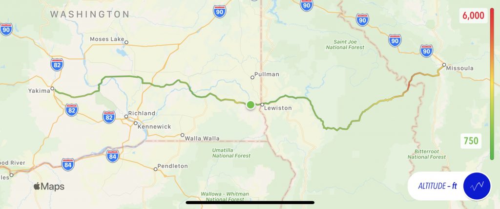
Map
Here’s today’s map with an altitude overlay.
Tomorrow
Who knows? I’ll wander around western Washington a bit and see if I an find a Covid test what can take place on Friday before I head to the Par-Tay.