Map
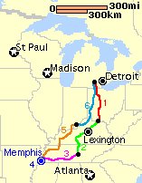
Here is the map for the Memphis Cruise. Click on the routes on the map to navigate to the trip report for that day.

Retrospective Note (2016): Back in 1997, Apple Maps and Google Maps didn’t exist yet. Consequently, the map is tiny and based on a screen shot of a MapQuest map.
Posts
- Memphis Cruise Preview
- Memphis Cruise Day 1
- Memphis Cruise Day 2
- Memphis Cruise Day 3
- Memphis Cruise Day 4
- Memphis Cruise Day 5
- Memphis Cruise Day 6
Statistics
Total number of days: 6
Total miles: 1,807
Shortest Day: 62.9 miles (Day 4 – Around Memphis)
Longest Day: 400 miles (Day 6 – Corydon, IN to Ann Arbor, MI)
Average Miles/Day: 301.2/day
Number of States/Provinces visited: 5 (MI, OH, KY, TN, IN)
Average Miles per Gallon: 43.12
Photos

Blatently Poser-fied vanity shot of Ghost and the Cruiser ready to take off for Memphis, TN. Michelle took the photo.

A crappy photo of the bridge at Aberdeen. That’s Maysville, KY on the other side of the river. A railroad freight mainline runs on the other side of the river, so I had company all night. This photo sucks because I used a disposable camera. After the film was developed, I dropped the photos (and my Newton 120 PDA) off the Bike on I-96 east of Grand Rapids, MI. Several cars/trucks ran over the photos (and my Newton) before I could retrieve them. Instead of scanning the negatives to a Photo-CD, I scanned the abused photos on a flatbed scanner at a local Kinkos Copies. Again, this is why this photo sucks.

The Pyramid is where I saw the exhibit of Titanic aritifacts. This photo sucks because I used a disposable camera. After the film was developed, I dropped the photos (and my Newton 120 PDA) off the bike on I-96 east of Grand Rapids, MI. Several cars/trucks ran over the photos (and my Newton) before I could retrieve them. Instead of scanning the negatives to a Photo-CD, I scanned the abused photos on a flatbed scanner at a local Kinkos Copies. Again, this is why this photo sucks.

A shot of the I-40 bridge crossing the Mississippi River. This photo sucks because I used a disposable camera. After the film was developed, I dropped the photos (and my Newton 120 PDA) off the bike on I-96 east of Grand Rapids, MI. Several cars/trucks ran over the photos (and my Newton) before I could retrieve them. Instead of scanning the negatives to a Photo-CD, I scanned the abused photos on a flatbed scanner at a local Kinkos Copies. Again, this is why this photo sucks.

Commerce is alive and well on the river. This photo sucks because I used a disposable camera. After the film was developed, I dropped the photos (and my Newton 120 PDA) off the bike on I-96 east of Grand Rapids, MI. Several cars/trucks ran over the photos (and my Newton) before I could retrieve them. Instead of scanning the negatives to a Photo-CD, I scanned the abused photos on a flatbed scanner at a local Kinkos Copies. Again, this is why this photo sucks.

Early in the afternoon, I took a drive past Graceland, home of the rock-&-roll God Elvis Presley. The mansion looked like, well, a mansion. If it weren’t for all the supporting fixtures of tourist exploitation across the street, you’d assume that this spread belonged to Mary Tyler Moore’s plastic surgeon (or some other rich and mundane individual). I turned around, and snapped a single picture as I drove back downtown. Not bad for 20+ MPH on a motorcycle in heavy traffic! This photo sucks because I used a disposable camera. After the film was developed, I dropped the photos (and my Newton 120 PDA) off the bike on I-96 east of Grand Rapids, MI. Several cars/trucks ran over the photos (and my Newton) before I could retrieve them. Instead of scanning the negatives to a Photo-CD, I scanned the abused photos on a flatbed scanner at a local Kinkos Copies. Again, this is why this photo sucks.


