
Yesterday I flirted with two storm fronts and managed to stay dry. Today, the weather gods had me right where they wanted me. All I wanted to do was take a swing by my alma mater and get part-way home.
Pre Ride
I started the day lazily. A quick look outside, to the north, showed overcast skies and a dry parking lot. I showered and re-braided my messy hair. I was sick of wearing my last long-sleeve t-shirt, so I put on a clean short-sleeve t-shirt even though I suspected that it would still be unusually cool today.
Oh, the weather…
A quick check of the current radar revealed the horror story below.
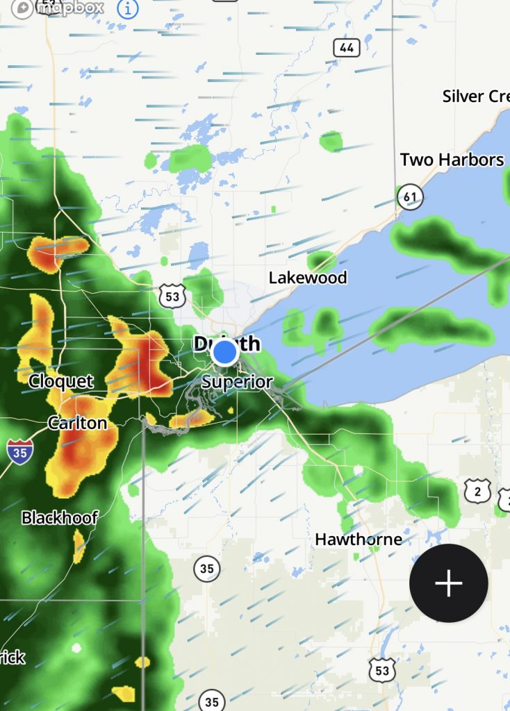
The storm front was coming from the southwest and was traveling northeast, right towards my location. My path along US2 to the east would take me away from it, but there was already light rain in that direction. If I rode through it, I should break out of it an into dry weather.
But only if I left right, fucking, now.
The Ride
I slapped on my gear, loaded the Bike, and pulled out of the parking lot, right past the Duluth Grill where I’d wanted to get breakfast (it came highly recommended by the bartenders at OCM Smokehouse last night).
It was already misting and the details in the distant south were rapidly disappearing behind the rain that was falling in that direction. As I turned on the I535 bridge from Duluth to Superior, Wisconsin, the winds picked up and pushed me all over my lane on the bridge. Down the other side in Superior, I was stopped by a light where I was going to merge onto US2 east. Just as the light turned green, the heavier rain found me… sans raingear.
Luckily, I was able to hit green lights through most of downtown and emerged from the heavy rain and back into the mist again. Fairly soon, I exited Superior and was able to put some distance between me and the downpour.
Taking stock of the situation, I had a nearly full tank of gas, no food in my belly (unless you count last night’s nice dinner), and plenty of water on board. Gear-wise, I had on my normal Leathers and my heated gear (though it wasn’t on). The heated gloves are also waterproof (GoreTex liner) so they are fine to wear in the rain if necessary. As cool as it was going to be today, I didn’t want to get soaked, so the strategy was going to be ride in the light rain, but if anything heavy caught me, I had to put on the raingear.
There wasn’t anymore significant rain to the immediate northeast, so I was going to swing by the town of my college days in Houghton, Michigan (Michigan Technological University). After I got there, I would have probably painted myself into a corner where there’s be nowhere to go without riding through some healthy amounts of rain. I’d decide what to do once I got there.
US2 across northern Wisconsin doesn’t follow the irregular coastline around the Apostle Islands (WI13 does that), but stays a few miles inland instead. The highway rolls through the forest from one small tourist town to another. If the town is near a river, it will feature canoe and kayak rental. If the town is near a ski area, it’s summer businesses support hiking and mountain biking. Aside from the normal RV parks and general stores, the constant presence in these towns, dormant for the summer months, is snowmobile rentals. These towns often make or break their entire year based on how much snow they get during the winter. More snow means more snowmobile tourists. Some businesses, like the more atmospheric bars in the area, surrounded by motorcycles in the summer, find themselves surrounded by snowmobiles in the winter, trading Hell’s Angels for Frosty’s Angels.
I saw a lot of small motels and eating establishments with real estate for sale signs in front of them, including two places where I’ve stayed/eaten in previous years on similar trips. I assume the closures are due to the ongoing Covid challenges from last year, but I can’t be certain without more research.
I got a lot of practice changing traction control modes on the Nightowl today. One minute the roads were dry. The next I was in some misty rain. The next I was fighting the road spray being churned up off the saturated road surface by the vehicles I was trying to pass. I was constantly switching between Road and Rain modes. The good news was that the Michelin Pilot 4 GTs were holding fairly well, even with several thousand miles of wear on them. (They still don’t feel as sure-footed in the wet as the Metzeler Roadtec 01 SEs, but they’re not bad.)
In passing Ashland, Wisconsin, US2 hugs the coast of Chequamegon Bay off Lake Superior. Even in the protection of the bay, the water was choppy in the northeasterly wind. I hadn’t noticed the wind very much so far because I’m no longer out on the plains; I’m in the forests and reasonably protected from most of the passing winds.
The Bad River Casino (Lake Superior Chippewa tribe) east of Ashland looked pretty dead but it was just lunchtime on a Friday. Overall, the tribal buildings and businesses looked to have survived the Covid pandemic better than some of the surrounding small towns.
Nearing the Michigan border, it looked like it the sun might actually burn through some of the remaining overcast. It never I’d, but teased the possibility several times.
At the Wisconsin/Michigan border, you’ll find the towns of Hurley, Wisconsin and Ironwood, Michigan. These towns would be one entities were it not for the inconvenience of a state line between them. Back in college at Michigan Tech, Hurley was a common road trip destination because, back then, the drinking age in Wisconsin was only 18 instead of 21 in Michigan.
East of Ironwood, US2 takes a southerly crossing of the Upper Peninsula. I wanted to head up towards the Keweenaw Peninsula on the north side, so I turned left on MI28 at Wakefield. Last time I was up here, there was a really old community center that I’d remembered from my youth that was in disrepair but still standing. This time, I noted that it was gone entirely. Everything changes.
The periods of real rain and wet roads were more common now. The sky wasn’t really any darker, but a quick check of the weather radar showed pockets of rain all around me. I reminded myself to make the call and don the raingear if things got much worse. For the moment, I wasn’t getting soaked, but that could change fairly quickly.
At Bruce Crossing, I turned north on US45 towards Ontonagon and Houghton. A bit north, US45 heads over to dead end at Ontonagon; I veer right on MI26 towards Houghton.
Getting out on the Keweenaw Peninsula, the landscape get hillier, but is still largely forested. There are occasional reminders of the huge amount of mining for copper and iron ore that took place here from the mid 1800s through the mid 1900s. There will be an abandoned shaft house, or a huge concrete foundation with nothing on it, or sometimes just a lone smokestack rising from a field with nothing but grass and trees surrounding it.
As I get closer to Houghton, I ride through another patch of heavier rain. I may get in front of this stuff for the moment, but it’s going to catch me good if I stop for long in Houghton.
Cresting a hill south of Painesdale, I can see the Quincy shaft building high on the hill overlooking Hancock. It was standing back in my college days too, but back then it was a rusting hulk. Sometime in the 2000s, the community raised money to recover the outer walls with fresh corrugated galvanized sheets, bringing it (visually) back to it’s hey-day appearance. On a sunny day, you can see the sunshine reflecting of of it from as far away as L’Anse on clear day. Today, it was just a nondescript looming monument off on the high horizon.
I pulled into western Houghton, passing the Copper Country Mall and noting that several of the shops there now are completely different from what I remember from a visit just a few years ago. That visit was after a horrible flood problem where dozens of buildings were damaged when water rushing down gullies carried lots of the hillsides with it. This time I was looking at those same scenes and seeing a new building, or a new retaining wall, or a new drainage tunnel where only a tiny culvert existed before. Progress; live and learn.
They’re working on the lift bridge that connects Houghton to Hancock and the rest of the Keweenaw Peninsula north of the Portage Canal. The resulting lane closures on the busy bridge makes for long lines of cars trying to get across the bridge. Luckily, I have no need to cross the bridge today (perhaps if the weather was better). I divert past the line-up and head into downtown Houghton.
I managed to make it here from Duluth on a single tank of gas, so I’m under 10 miles to empty. I stop at the Kryst station near the edge of downtown and fill up.
My lunch destination is The Library Bar and Restaurant. It was popular when I went to school here. It was tiny back then with a limited number of tables. It burned to the ground and was rebuilt into the much larger and modern form that it has now.
I find a parking spot in the sloping parking lot and have to angle the bike uphill so it can sit on the side stand without the wind tipping it over. My gloves are wet on the outside, but not soaked through. The rest of my is basically dry.
I find a table and notice from the groups of other patrons, that this mush be move-in weekend at Michigan Tech. I remember move-in weekends being some of the hottest of the year, with everybody dashing out to the mall to buy fans to try and keep their new dorm rooms cool. Not this year.
I order a Philly cheesesteak sandwich with truffle fries and a Diet Coke and eat while listening in to the conversations from the other tables. Meanwhile the heavier rain arrives and starts soaking the parking lot.
By the time I’m done eating the checking the weather radar, the picture isn’t pretty. There’s a large area of steady rain across most of the Upper Peninsula. As predicted, I’ve painted myself into a corner; there’s no escaping it, unless I want to try and stay here tonight, which won’t be easy on move-in weekend.
I look forward on the radar forecast and see that the south side of the UP has the best chance of being out of the rain by tomorrow morning. I look around and find a reasonably priced motel room in Gladstone, just north of Escanaba and a stone’s throw from Lake Michigan. That’s my new destination… but I’ll have to add the raingear if I don’t want to arrive a drowned rat.
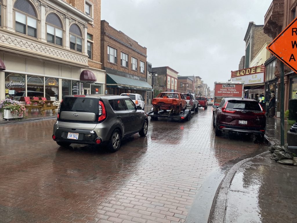
It’s raining when I exit the Library. I walk up the hill to take a single photo of the congestion downtown due to the bridge construction.
Back down the hill, I’m out in the parking lot putting on the raingear. If I could invent a good set of raingear that goes on and off in seconds, I’d become a rich man. Putting it on is tedious and time consuming, which means the gear you’re covering is just getting wetter the longer it takes. Ironic.
With raingear on and back on the bike, I pull out of downtown Houghton. The line of cars trying to get across the bridge now stretches all the way back to campus. Mercy. I’m glad I’m not in that mess.
The miles along US41 south of Houghton seem to pass faster since they’re so familiar. I’m making decent time, in spite of the we roads and occasional construction zones. Soon enough I’m on the west coast of Keweenaw Bay off Lake Superior, pulling into Baraga and rounding the base of the bay into L’Anse. This bay is not as well protected from the rest of Lake Superior and it looks downright nasty out there. The whitecaps start about 200 yards/meters out and carry all the way to shore where the splash reaches high and sometimes lands on the highway.
At the top of the hill exiting L’Anse, I make my only planed stop for this leg of the trip: the Hilltop Bakery and Restaurant. The food here is OK, but that’s not why I stopped. This bakery makes the biggest sweet rolls in the UP. They’re not just huge, they’re damn good. After my big lunch, I figure this can be dinner in my hotel room later tonight. I double-bag the roll (it’s already in plastic wrap) and tie it to the camp bag on the passenger seat. It should survive there for the next 90 minutes.
The sleepy towns between L’Anse and the greater Marquette metro area look like they’ve survived Covid a little better than those on the west side of the UP. I see fewer shuttered businesses and the big resorts appear to be back open and full of campers.
The traffic patterns for US41 around Marquette have changed quite a lot. Several lights have been replaced with roundabouts and it looks like they may be making it a boulevard for an extended section. I could see why Waze didn’t want me to take this route; it’s messy and slow now, especially in the rain.
Along the Lake Superior coast, the wave action is even higher than back in Keweenaw Bay. I wouldn’t want to be out on the lake today, and it’s only late August. Just wait until November; that’s when the shit really hits the fan.
It’s after 6pm now and the traffic south of Marquette is near non-existent. The evening commute is done and all the tourists have ended their days early to escape the crappy weather. I make good time south on US41 towards Gladstone. I expected to start seeing deer near the road, but the weather must have been keeping them down too. About 20 miles out of Gladstone, the rain finally tapered off to nothing, making the remaining few minutes more enjoyable.
I pulled into the motel parking lot at about 7:15pm.
Post Ride
I moved my luggage to the room and started peeling off the layers. The rain suit was hung up to dry. The bottom few inches of my chaps were also wet, so they’re set out to dry as well, instead of being rolled up per normal. The crotch of my jeans were still wet from all the way back to the first five minutes of the ride back in Duluth; they’re hanging up to dry as well. The gloves are soaked, but only on the outside.
Curious, I check out the current weather radar to see how it ended up.
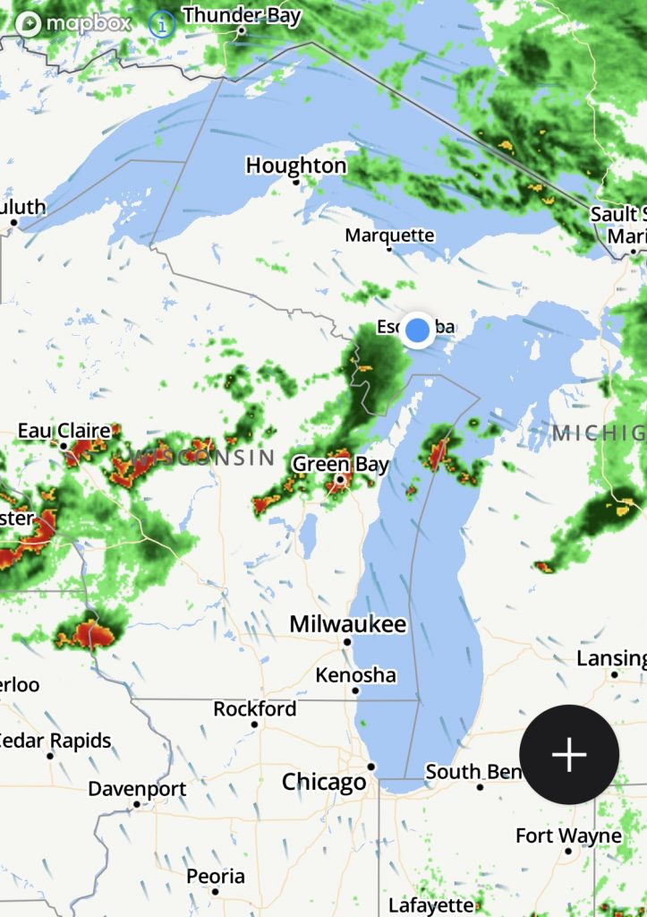
I checked the sweet roll and it didn’t suffer any damage from the wet ride down. Bonus points: my room for the night has a microwave so I can heat up the sweet roll for dinner. Cool.
I eat and get down to writing.
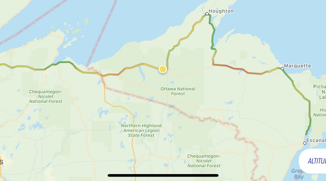
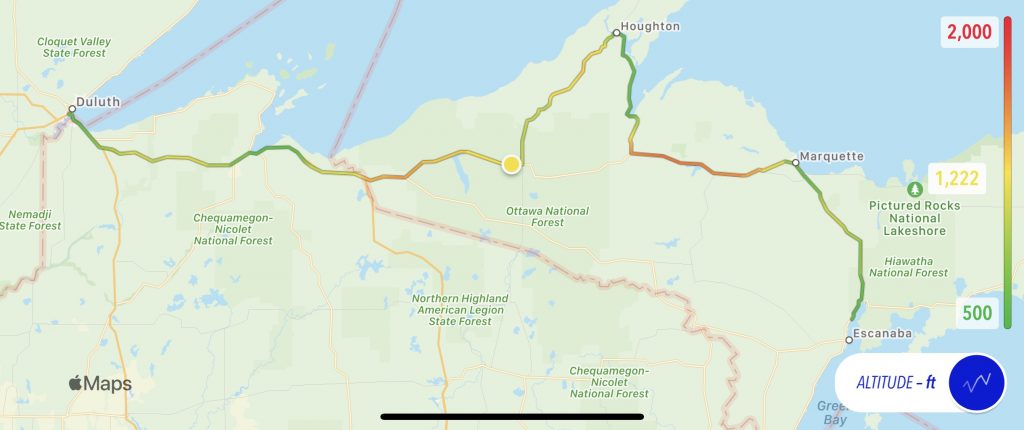
Map
Another day, another map with an elevation overlay. Not much variation here, just a few higher areas near the Porcupine Mountains and the Huron Mountains.
Tomorrow
The end finally arrives; it’s time to get home.