
Today’s route is simple: US2 east. The scenery is far from simple: through the foothills to the continental divide at Glacier National Park to the endless grain fields of northern Montana.
Pre Ride
I woke up shortly before the 8:30am alarm went off to the sound of a OpsGenie alert from work. When I get back, I need to create a task to remove vacationing personnel from the on-call schedule.
My neck had been a bit stiff since the day before yesterday, and this morning was no exception. I jumped in the shower, not because I needed another shower after last night’s, but because I wanted to cook the muscles in my neck under hot water.
Ahhh, that’s better.
I proceed to pack up. It’s a brisk, clear day outside with temperature sitting at 53º F. This would dictate the continued need for the heated gear today. Looking at other towns along today’s tentative route saw the highest temperature in the low 70ºs F; definitely a day for heated gear.
Aside: I could layer up and survive without the heated gear, but anytime you’re outside at highway speeds at anything below 70º F, you’re going to lose body heat slowly over the course of the day. There’s no arguing with the laws of thermodynamics; they always win. So, you macho assholes out there saying, “I wouldn’t be using heated gear”, more power too your mildly hypothermic ass at the end of the day.
I leave the motel at 9:30am and gas up in Bonners Ferry, ensuring that I wouldn’t have to stop for gas… probably until the other side of Glacier National Park.
The Ride
East of Bonners Ferry, US2 follows the Kootenai River all the way to Libby. This makes for a nice ride through a river valley with increasingly higher mountains on either side. With the blue sky and the few puffy clouds above, it was a gorgeous morning to ride.
At the Montana border, I lost an hour to the transition from Pacific to Mountain time. Not long after, I passed the parking lot for the Kootenai River Falls trailhead. I’d passed it before on less ideal days, always intending to stop one day… and that day should be today.
I slow down and pull an U-turn and pull into the trailhead parking lot. I had no idea how long the trail was to the falls; for all I knew, it was a four mile hike. Somehow, I thought it wouldn’t be that long, so I left my jacket, chaps, and helmet on for the walk down the to falls.
In retrospect, I should have left the helmet, and perhaps the jacket liner too.
The trail wasn’t that long, but it was all downhill to the falls… which meant all uphill back to the trailhead. Needless to say, I was plenty warm and more than a little winded when I returned to the trailhead parking lot.
Anyway…
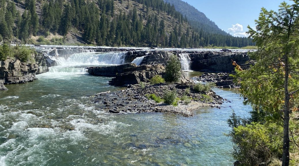
The trail itself was cool because it included a bridge over the BNSF mail line that follows all of US2 across Montana. The falls itself was impressive more for breadth than width, but was still impressive. I took several photos, which are included below. Enjoy.
The Kootenai River Falls from the top of the trail. 
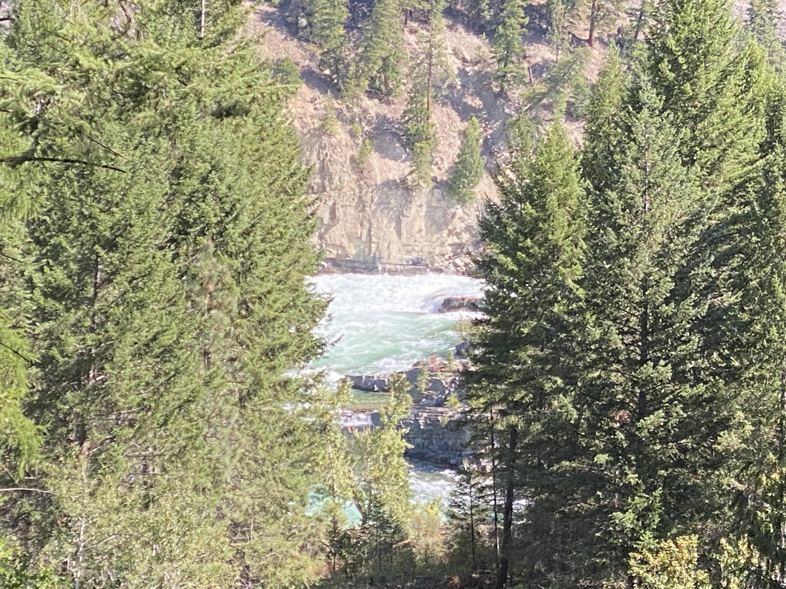
The BNSF main line at the Kootenai River Falls. The path includes a bridge over the main line. 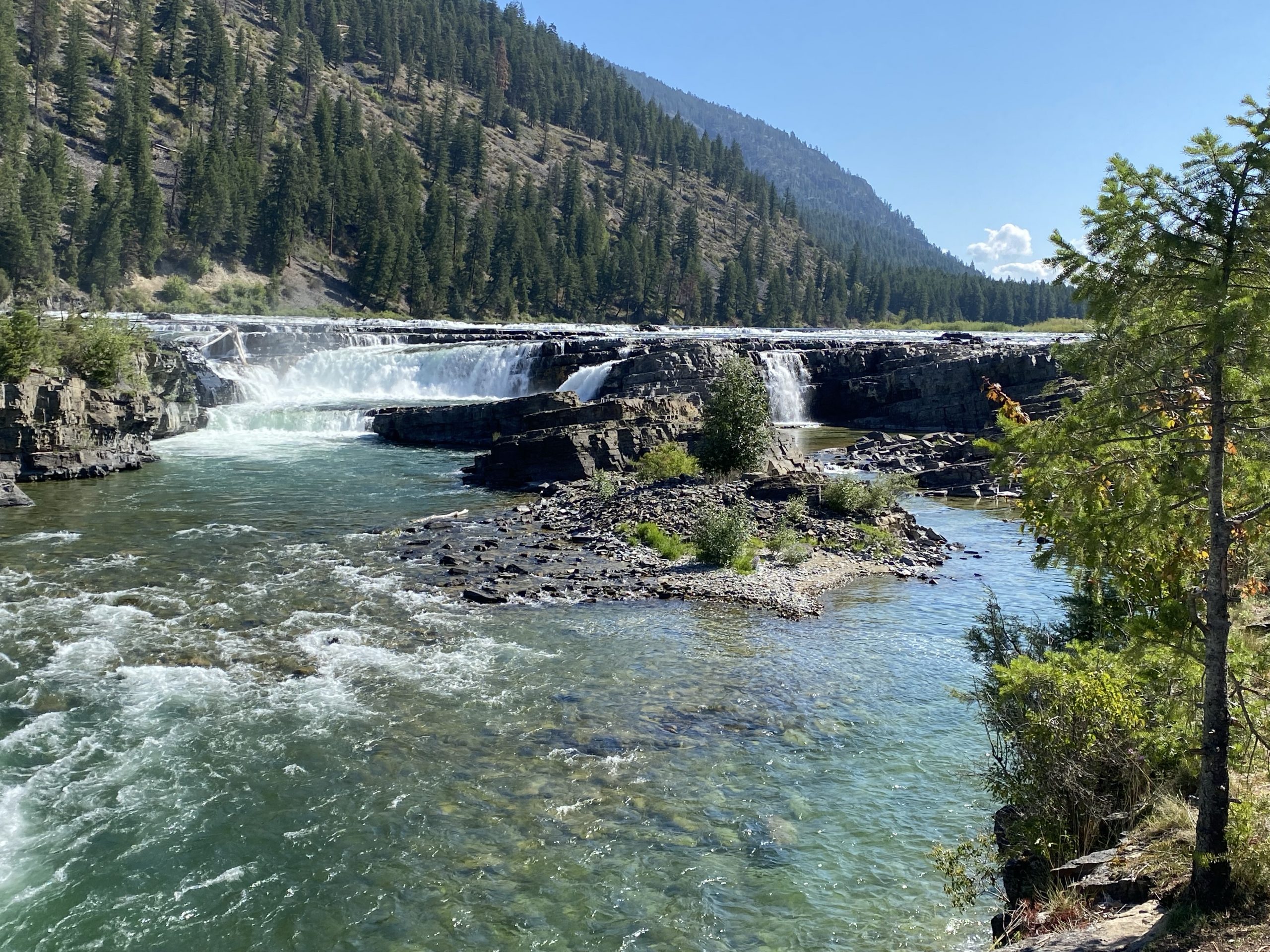
The right half of the Kootenai River Falls. 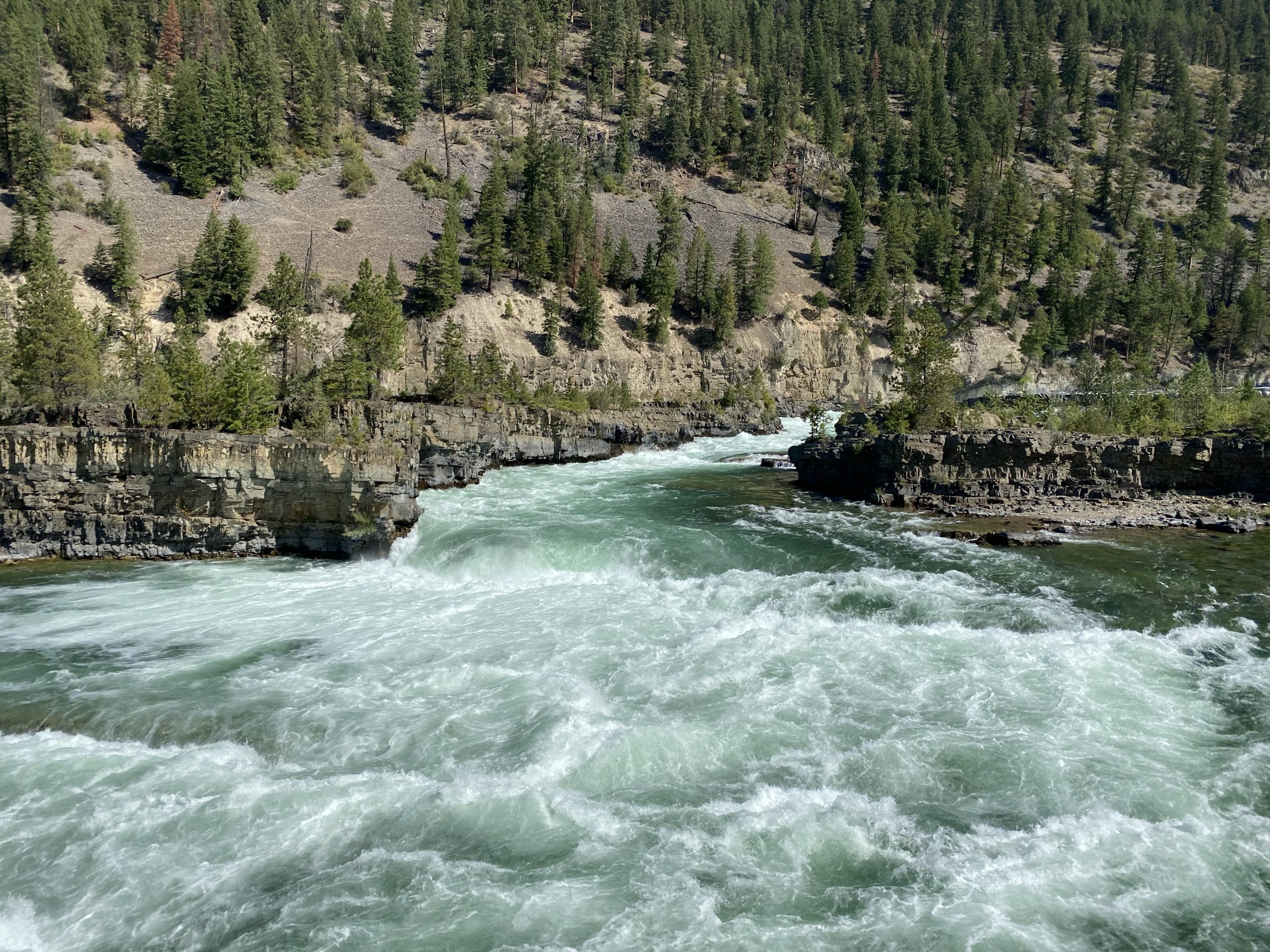
The left side of the Kootenai River Falls. 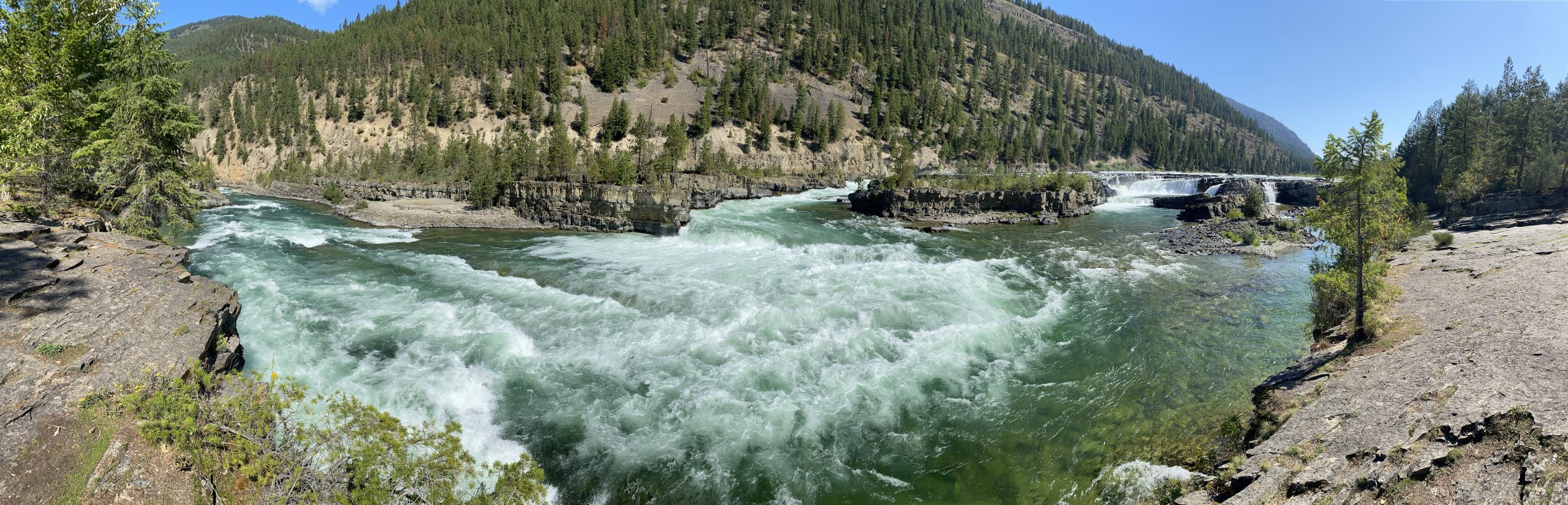
A panoramic photo of the Kootenai River Falls.
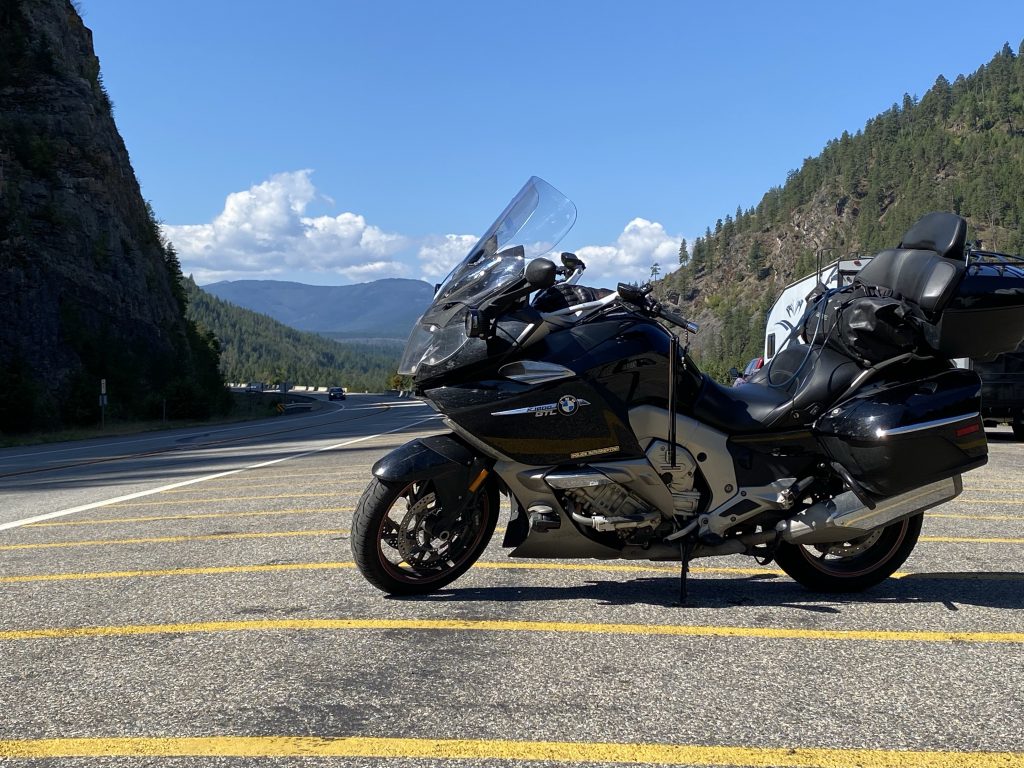
Back at the trailhead parking lot, I snatch this quick photo of the Nightowl in this valley.
Further east past Libby, I rode along the upper and lower Thompson Lakes. Both were completely still since were was almost no wind, which meant they were like mirrors reflecting the mountains on the other side of the lakes. I considered taking a photo or two, but I’d just fought around a line of gravel trucks and didn’t want to pass them again. Sorry, no photo.
I bypassed down down Kalispell on US93 Alternate and picked up normal US93 north of Kalispell. That took me with dispatch to Whitefish, where I turned east on MT40 towards Columbia Falls and a reunion with US2.
Columbia Falls is familiar since every Sunrun that we had between 1997 and 2004 managed to run through here as a staging point for visiting Glacier National Park. It’s a little more built up now, but most of the same campgrounds, motels, gas stations, restaurants, and bars are still there. I was happy to see that none of our old haunts had succumbed to Covid-induced closure.
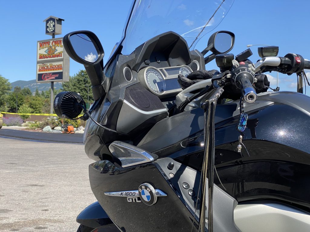
Towards the east side of Columbia Falls, I found The Nite Owl diner and it’s Back Room dinner counterpart, still in business and going strong. I’ve lost count of how many breakfasts and dinners were enjoyed in the walls of these two establishments. I got a chicken sandwich with fries and reminisced over previous meals with friends and the loud laughter that usually turned heads in the establishment.
Back out in the parking lot after lunch, I paused to take a nice crossover photo of my Bike and the diner sharing a namesake.
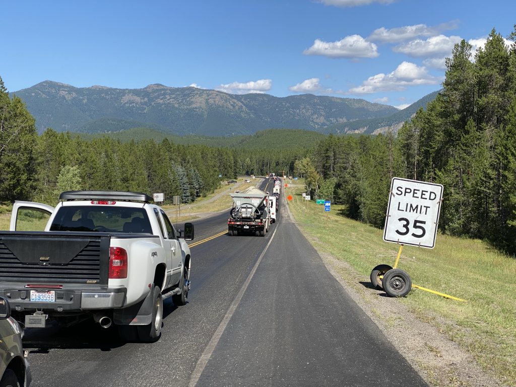
I exited Columbia Falls to the east and took US2 into the canyon towards Hungry Horse. I was prepared to capture some cool video of the ride through this short canyon… but construction foiled it all. The captured video isn’t nearly as interesting… at 30 MPH the entire way. Bummer.
Hungry Horse doesn’t look much different from back in the Sunrun days. The old Canyon RV and Cabins is now Glacier… something or other. (Horrible graphic design on the sign, you can’t read it from the highway because the font is too fine — graphic design grade: F.)
About five miles west of West Glacier, I got caught in the first of two one-lane pilot car regions between Hungry Horse and West Glacier.
Back at The Nite Owl over lunch, the Old Dude sitting behind me said I’d be able to get through the Going-to-the-Sun Road if I just pulled up, especially this late in the day. I decided to give this a shot. I pulled up and the ranger made a sad face and reported gave away the last allotted reservation for the day about 20 minutes ago. I’ll deal with US2, though it’s a bummer because the photos on this clear a day through Logan Pass would have been phenomenal.
I continued east on US2 around the south side of Glacier National Park. It’s still pretty, and it follows the BNSF main line over Marias Pass, which is fun for railroad nuts like me. It looks like I’m going to make decent time when I hit another single-lane pilot car construction zone. Then I hit another… and then another. It’s a miracle I got through the damn pass before Christmas.
The good news was that my route through the pass saw several BNSF trains making their way over the pass; not one or two, but five trains, all eastbound, between West Glacier and Browning, where I finally saw a westbound waiting on a siding. I wondered how long that westbound would have to wait before getting clearance through the pass.
I gassed up in Browning and scoped out my possible stopping points for the evening. The original plan was to get all the way to Glasgow, Montana, but that would have required 560 miles of total travel and a much higher average pace. I could stop early in Shelby, Montana, which is on the US2/I15 interchange and has plenty of motels and campgrounds (I could camp if I wanted since it was so cool today), but that was only 60 miles away and would be cutting the day pretty short. In was completely caught up on trip reports, so I only had to write up today’s report this evening, so I don’t need extra time at my destination.
Right between Shelby and Glasgow is Havre. It’s not exactly the garden spot of the state, but it’s a decent sized town, has plenty of motels and eateries (including an Irish pub I’d dined in the last time I stayed there), and it has a huge BNSF rail yard for geeking out on railroad stuff. It would be 160 miles away, but from here the route gets wide open and the pace should pick up; I should be there by 7:30pm.
I booked a room at the Super 8 in Havre.
Having committed to my destination, and armed with a full tank of gas that will easily get me to said destination, I hop on the Nightowl and head east with divine purpose.
As suspected the traffic volume dropped off and the scenery opened up, allowing for long stretches with the cruise control set at a just-low-enough-to not-get-pulled-over speed. Passes of slower traffic were near-effortless. In several cases, I simply made the lane change into the opposing lane, passed the vehicle, and merged back into my lane without ever moving the throttle or adjusting the cruise control.
Even before you get to Browning, you can tell that the fun in the mountains are over. The landscape gets less and less hilly and forested, giving way to broad expanses of never ending wheat fields. Earlier in the summer, even the wheat fields can hold visual interest; you can see the wind currents near the road by watching the wheat move in the breeze. But now it’s late August and the harvest season is near it’s end. The wheat fields I’m passing today are all harvested, which means the landscape is static stalks of cut wheat. It looks like the entire landscape got a crew cut.
As I neared Cut Bank, the profile of the craggy peaks of the mountains in and around Glacier National Park got lower and lower on the horizon. I was fully aware that the path home to Michigan would, literally, be all downhill from here. The next mountains I might see would be the Porcupine Mountains in the western upper peninsula of Michigan… and those would barely be called foothills out here.
Every time I travel west, I look forward to finally getting to the mountains because they’re so damn much fun to ride in. When I finally turn home and have to say goodbye to them, it’s like saying goodbye to a friend I only see once or twice each year.
The entirety of US2 in Montana is built along the path of the aforementioned BNSF main line (the old Great Northern mainline for those who give a damn about such trivia — they called this the Hi -Line). As such, I kept track of the railroad traffic I encountered, most of it westbound.
In Cut Bank, I was going to pause to take a photo of the impressive train trestle across the Cut Bank Creek there. Even though it’s considered a mere creek, the Cut Bank Creek has cut a quarter-mile wide and 80 ft deep valley into the surrounding prairie. Rather than take the railroad track down into that valley, the railroad simply built this high trestle over it. I confess, I was lazy, so no photo.
I crossed I15 in Shelby and was about to exit town to the east when I encountered the westbound passenger train, presumably the Amtrak Empire Builder. I waved at the train, but the tinted windows prevented me from seeing if anybody waved back.
East of Shelby, the last of the traffic I had to maneuver around was gone. I rode with near impunity, keeping the cruise control set for 10-20 miles at a time. The remaining ~100 miles were going to pass quickly.
Most of the tiny towns along this stretch are little more than a group of houses and a grain elevator. These are almost pure railroad towns and simply wouldn’t exist if they weren’t on the main line. In most cases, the town looks healthy and the grain elevator looks active, often with several extra temporary grain pick up bins in the drive next to the grain elevator so they can accept grain from multiple trucks at the same time (again, the harvest rush probably ended in the last week). In some cases, however, the grain elevator is shuttered, it’s outbuildings falling down or scrapped, and the surrounding town looks like it’s on it’s last legs. The tracks that were once used to house dozens of grain cars filled to the brim are now occupied with surplus oil, logging, and building product cars; basically a surplus parking lot for the railroad.
The waning sunlight usually puts me on full alert for deer and other creatures that like to run across the road in the early evening. Out here, however, there aren’t any places for the deer to hide, so they aren’t as much of a worry. Having said that, I did slow down for a group of Pronghorn Antelope in the ditch next to the road. They just looked at me like I was an obnoxious bystander molesting their evening meal.
About 30 miles west of Havre I caught a BNSF intermodal train heading east. It was probably going about 60 MPH, so it took several miles for me to traverse it’s mile-long length and get in front of it. It was 100% containers, which makes for a nicely varied and colorful train to watch, even from a distance. I wondered how long it would take for it to catch back up to me when I stopped in Havre.
I pulled into the Super 8 parking lot in Havre at 7:20pm, with the sun still low over the western horizon.
Post Ride
I walked into the motel office with my modular helmet closed, out of habit because Washington recently went back to everybody wearing masks inside. The receptionist was mask less, which prompted me to remember that I’m in Montana… and far northern Montana at that, which means a more isolationist approach to the entire pandemic thing, which means no masks… anywhere.
I checked in, unpacked, and consulted the Yelp app for eating establishments that would be open after 8pm. Lucky for me, the Murphy’s Irish Pub down the road was still open. I’d eaten there a few years ago when I spent a night here and the food was good… and the open bar was well stocked with a nice selection of bourbons and single malts. Their kitchen was open until 9pm and the bar didn’t close until 11pm.
Decision made.
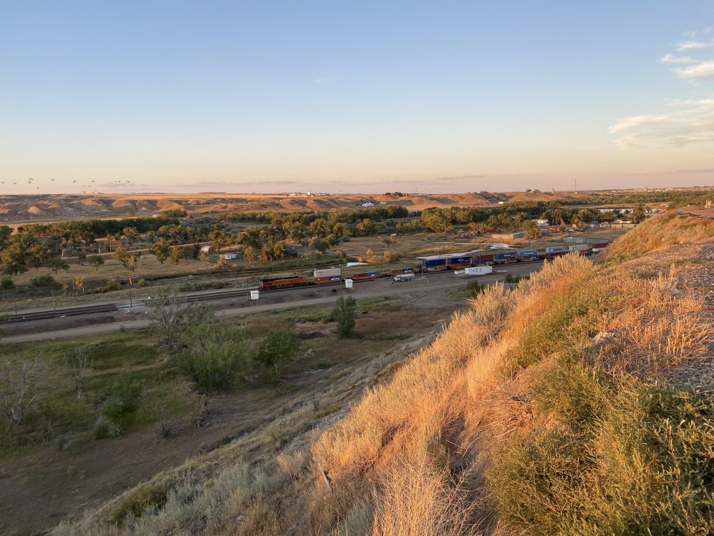
Murphy’s sits on a bluff overlooking the Milk River valley where the bulk of Havre exists, along with the aforementioned BNSF rail yard. I walked to the far side of the Murphy’s parking lot and took a quick photo of that eastbound intermodal train sitting in the yard in the valley, it’s single pusher diesel idling in the quiet evening air.
I found a table at Murphy’s and ordered a Old Fashioned made with Woodford Reserve. For dinner, I ordered their Italian Melt, which is basically a traditional Italian submarine sandwich, but toasted and on an onion bun. I got mashed potatoes and gravy for a side. They had good WiFi, so I was soon uploading photos and feverishly adding captions and starting today’s trip report.
Since they were going to let me stay there a while after the kitchen closed, I ordered a second Old Fashioned and got back to writing.
Finally, with the trip report posted and shared to the laundry list of groups that I post to, I rode back to my motel room for a good night’s sleep.
Map
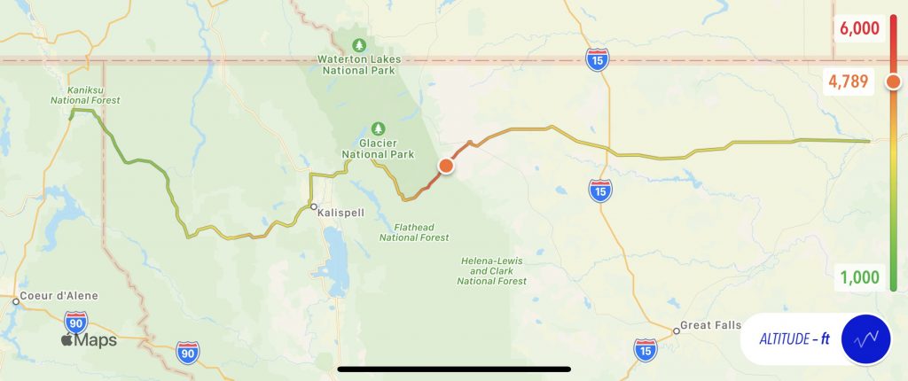
Here’s today’s map with an altitude overlay. With the exception of crossing the continental divide at Glacier National Park, there wasn’t much other elevation. There was, however, a long downhill as I got onto the plain later in the day.
Tomorrow
Lather, rinse, repeat… US2 east.