
With most of the eclipse watchers out of the area, I was looking forward to a enjoyable day of riding through the mountains of Idaho and Wyoming.
Breaking Camp
My alarm went off at 8:30am (I am on vacation, after all) and I went about the tasks of getting down the road. That meant stowing the sleeping bag and other bedding in bags, deflating and rolling up the Thermarest, and taking down the tent. None of these tasks are all that daunting, especially when you’re working in the cool of the morning and the sun isn’t up over the ridge to your east.
I said goodbye to some of my fellow campers, fired up the Nightowl, and pointed the handlebars east on the Banks-Lowman highway.
Banks-Lowman Highway
The Banks-Lowman highway is a little gray line on most maps, connecting the more major highways of ID21 and ID55. In spite off it’s minor significance, it’s a great road weaving through the valley that holds the South Fork of the Payette River. The surface is in good condition and the curves are well marked for relative safe speeds, speeds that we, as motorcyclists, tend to abuse.
The valley is pretty open west of the wide spot in the road named Garden Valley (look for the Chevron station). This village is important since it’s about the only place along the roadway where you’ll get reliable cell service. I used it several times during my two-night stay at the Hot Springs campground in the nearby Boise National Forest.
East of Garden Valley, the valley narrows and the curves get a bit more fun, mostly 45mph sweepers that I would take in fifth gear. A bit further east and the curves tighten up a bit and form a long string of 30-35mph curves along a intermittent uphill climb. Towards the east end of the highway, as you approach Lowman, the valley gets tighter still and you drop all the way down into second to rail around several sequences of 25mph curves.
Taking all this first thing in the cool of the morning, with a bright sunny sky over head and the rolling South Fork of the Payette river along side, was a great start to the day.
Idaho 21
In Lowman, I turned left onto ID21 heading northeast towards Stanley, ID. Stanley was my original target for viewing the eclipse the day before, but serendipity occurred and I fell into that nearly free campsite in the national forest and had decided to not push my luck.
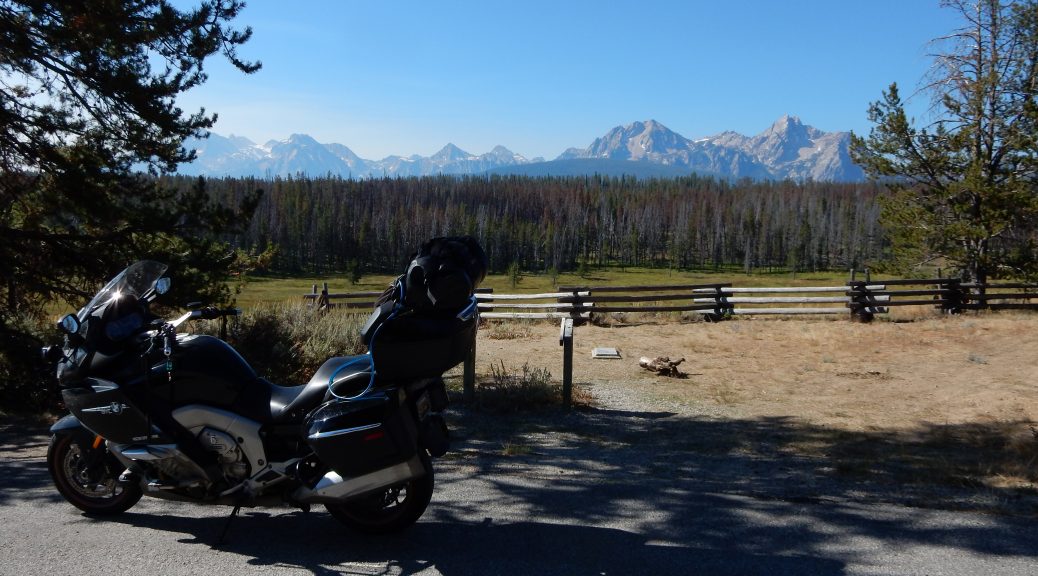
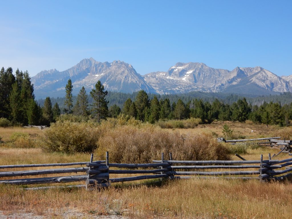
ID21 east of Lowman isn’t quite as tight as the east end of the Banks-Lowman highway was, but it was still full of sweepers as the road meandered along the same river to the north to go around (as opposed to over) the Sawtooth mountains . This is why the road heads north before turning back south to Stanley.
I was thoroughly enjoying myself so much that I almost forget to levera
ge a scenic overlook. I basically had the road to myself, so pulling a u-turn in the middle of the highway wasn’t a problem. I think the photos were worth it.


Soon thereafter, the road did the aforementioned curve back to the southeast and I was able to catch another look at the Sawtooth range from another vantage point.
I still had plenty off gas in the tank when I reached Stanley, so I turned left onto ID75 and kept going.
Idaho 75
This roads starts east just north off Stanley but then dives into a canyon holding the West Fork of the Salmon River. The curves here start tight but slowly relax as you wind the ~40 miles towards Challis, ID.
The character of the environment changes along this road too. In the canyon, it’s fairly green with predominately conifers and plenty of underbrush near the river. The river itself is well populated with fishermen and several rafts and kayaks running the man rapids.
The further you go, the more arid it gets, until there’s nearly no greenery at all, The low mountains around you are nearly barren, only a scattering of sage and other small brush. The valley floor, however still has the river running through it and the few farms along the way are well irrigated.
Years ago I took this road in the opposite direction on my first big trip west on my (then) new V-Rod (the Vector). I was still figuring out what that Bike’s capabilities were and ended up following a fellow rider on a BMW R-bike through the Twisties through the canyon near Stanley. It was fun to ride this road again.
US93 (and a Police PSA)
On the southern outskirts of Challis, ID, my route turned southeast as I turned right onto US93. While this road followed the pattern of running along a river, the valley holding the river was very wide and arid. There’s not a lot going on here except for rolling landscape and distant mountings of widely varying sizes on either side of the road. One of those mountains, Borah Peak, is the highest point in Idaho.
I was making pretty good time and the open spaces made it easy to pass the cars I encountered along the way. I was working my way around a series of four vehicles (two cars, a pickup, and an RV) when I noticed the pickup turn on flashing red and blue lights.
How did I miss that?
I found a spot with a little more shoulder than usual and pulled over. I was totally expecting a ticket since I was travelling at 10-15mph over the limit. Instead, I receive a genuinely concerned public service announcement about how the roads are still busier than usual with eclipse watchers and they aren’t watching for motorcycles. Consequently, I probably should be taking it easier than usual. So, drive the limit and have a nice day.
What a pleasant surprise!
I did drive the limit all the way to the headquarters of the Custer County Sheriff in Mackay, ID. At that point the officer turned off and I eventually went back to my evil biker ways.
I stopped for gas in Arco, ID but resisted the temptation to get lunch. I knew that I would be going through Jackson, WY later that day and one off my favorite pizza places, Mountain High Pizza Pie, was waiting for me there.
Shortly after Arco, I passed by one of the interesting pieces of history from early in the nuclear age. Off the highway to the south is a small nondescript building out in the middle of the desert, all by itself. This is the EBR-1, which stands for Energy Breeder Reactor #1. It was the first attempt to operate a nuclear fission reaction in a controlled fashion that was large enough to generate electricity for a community (the nearby Atomic City, which hardly a village). In essence, it was the proof-of-concept for every commercial nuclear reactor in the country.


In looking at how isolated and alone this facility is, you have to wonder: is it isolated to keep it secret or is it isolated because they weren’t sure they would be able to really make it work without the reaction getting out of control? Either way, they made it work.
US20/US26
Just after the distant view of the EBR-1, I turned left onto US20 and followed it into Idaho Falls. Waze did a pretty good job of running me around the town instead off through the middle off it. Soon enough I was cruising along on US26 to Swan Valley, where I turned north on ID31 for Victor and Teton Pass.
ID31
ID31 is yet another very enjoyable road that runs over a low series of mountains towards Victor. It wasn’t as spectacular as some of the earlier roads in this day, but it still lent itself to carving around corners with vigor. Great fun.
WY22
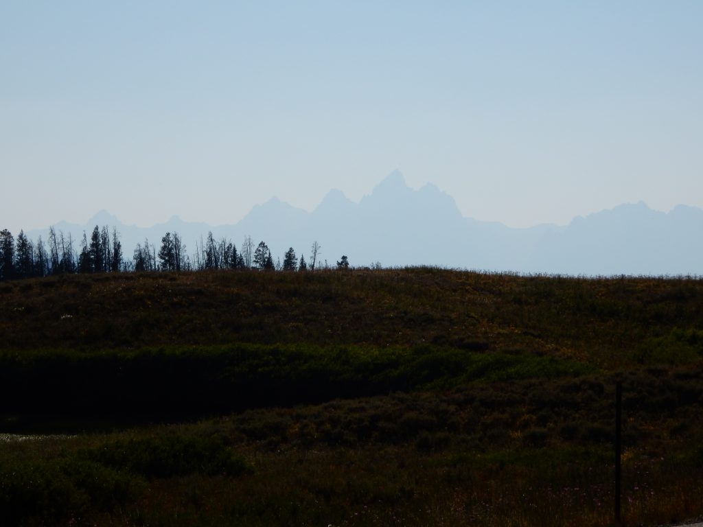
Just east of Victor, ID, you enter Wyoming and the road number changes from ID33 to WY22. The road slowly climbs a mountain pass until it gets very steep and curvy near the top of the pass. Then, quite suddenly, the view opens up and there’s a scenic overlook where you can gaze down into the valley and Jackson Hole in the distance.


Jackson Disappointment
I rode down into the valley and waded through the procession of vehicles running the only real route between Jackson Village and the actual town of Jackson. I was anxious to park the bike and fill my belly with a custom-made pizza from Mountain High Pizza Pie, which was right on the main drag.
Imagine my disappointment when my beloved pizza place was no longer there, replaced by some bar.
Crap. Shit. Hell. Damn…
But I’m still hungry.
Since it was late afternoon, there was a steady flow of cars exiting the national parks (Yellowstone and Grand Teton) to the north and entering Jackson. Consequently, parking spaces in town were few and far between. I though I may have seen a few workable eating venues, but noting that looked like it would be quick.
I was rapidly running out of town, so I threw up my arms and stopped at a Dairy Queen (grill and chill) and had a burger and fries. I was so frustrated that I didn’t even get any ice cream.
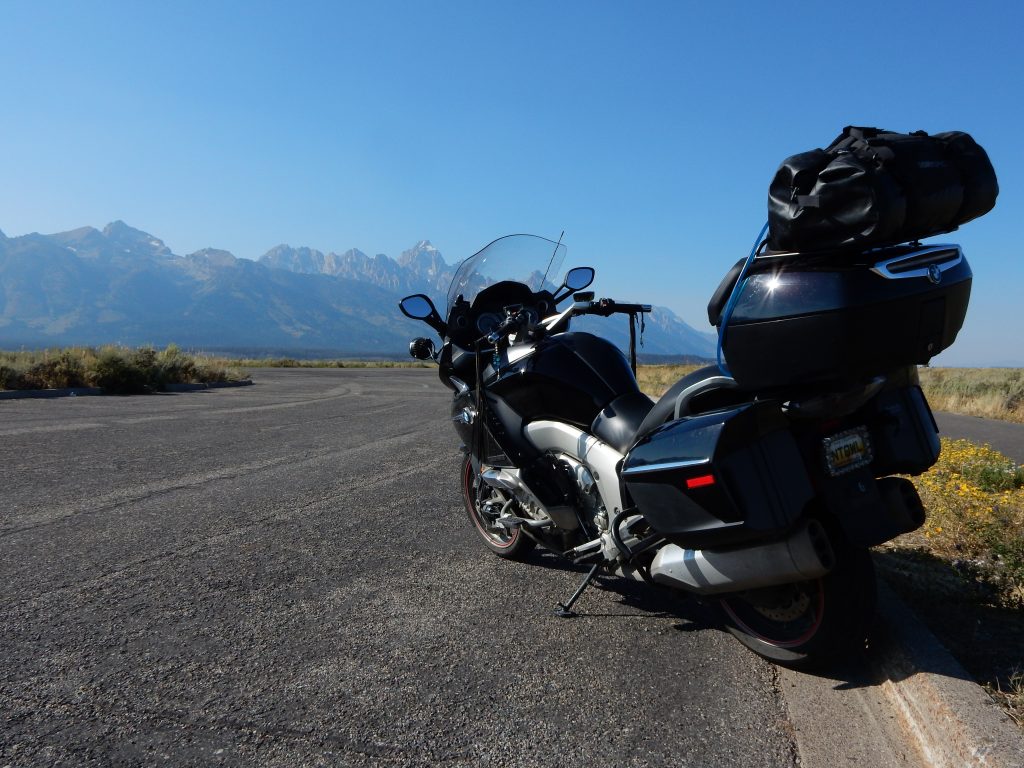
Traditional Teton Shot
Over the years, I’ve taken photos of all of my motorcycles in front of the Grand Tetons. Given the late afternoon hour, and the fact that I wanted to get west of the park before stopping for the night, and the fact that running late into the evening out here is not a good idea, I refrained from taking the route through the park and getting better photos. I took my one shot of the Nightowl in front of the mountains and continued down the road.
While there was a several-mile-long line off vehicles heading south, there were very few heading north, so I made good time to Moran Junction.
US26 (Wyoming)
Heading east out of Grand Teton National Park, US26 takes you over Togwotee Pass. The run up the pass isn’t twisty, but consists of wide sweeping curves that can be taken at highway speeds (or greater). I was enjoying the receding view of the Tetons in my rear view mirrors so much that I stopped at the crest of the pass to take one last photo of the Tetons before I returned to the boring flatlands of the American midwest.
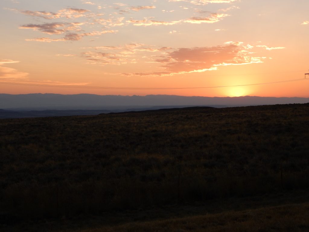
The rests of the evening ride was just a repeated reminder that my rides through the mountains were coming to an end. The Wind River range to the south moved further away from the road as I headed east. The setting sun cast a redish hue on the rock formations near Dubois, WY, dramatically enough that I paused for a quick photo.
I stopped for gas in the tiny berg of Kinnear, WY, and noted that it looked familar. Sure enough, my gas records indicate that I stopped here for gas while riding with Chuck after one of the Sunruns ages ago. It doesn’t look like Kinnear has grown much since then.
Just as I was pulling into Riverton, WY, my destination for the night, the sun was setting over my shoulder. I caught the last few direct rays in a photo before retiring to my hotel room for the night.
The Plan for Tomorrow
I was going to head across the middle of Wyoming and down into Nebraska. I think I need to perform a 12k service and I’m curious if I can gather the necessary fluids together to make that happen. If I do, it will certainly be easier along the busier I80 corridor.