
The second day of a four-day ride home from the SPITS run, started innocently enough but ended with the worst winter conditions I’ve ever encountered on a motorcycle.
The Plan
I already knew from the westbound leg of this trip and I could get from Denver to home in two days. Consequently, I needed to get at least as far as Denver today.
There was some rain forecast for north-central Colorado, but there was only supposed to be a few snow flurries in the higher elevations. That didn’t sound too bad. It certainly sounded better than riding through rain and high winds most of the way along the I80 corridor between Rawlins and Cheyenne in Wyoming.
The Ride Through Utah
It was plenty sunny, but not very warm. There were a few places where the temperatures crept above 70ºF but most of the day was spent in the low 60ºs F. I did put on a long-sleeved t-shirt but I left the heated gear in the saddlebags. This did leave me a bit chilly when crossing mountain passes, but I was comfortable for the vast majority of the Utah crossing.
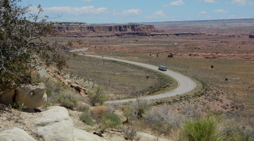
To get from Delta, UT to Salina, UT, you jump on I15 north for about 10 miles and then jog southeast through a nice valley towards Salina. This valley is about two miles wide with low mountains to the east and higher snow-capped (at least now in May) mountains to the west. The valley is mostly ranch land and I don’t usually see it this green since I tend to ride through here late in the summer.
Even before you reach I70 in Salina, there are multiple signs that warn eastbound I70 travelers that there are no services on I70 for the next 109 miles. Looking at your gas gauge, you’d better have enough to reach Green River, or you’re well and truly screwed. There’s simply nothing out there.
Actually, that’s a lie. There’s plenty out there but the multitude of canyons, rock formations, spires, vistas, cliffs, etc. fill your eyes, not your gas tank.
I stopped at one of the several scenic view points available along this route to take some photos. (If you have time, I strongly suggest that you stop at them all.)


")


There was a Hispanic family selling jewelry at this view point. I checked their wares for some nice turquoise beads for a bracelet I need to redo but they didn’t have anything like that.
Approaching Green River, I checked my miles-to-empty gauge and compared it to the next reliable source of petrol: Grand Junction, CO. The gauge read seven (7) miles more than I needed to reach Grand Junction, but that’s a pretty thin safety factor considering the distance is just over 100 miles. I took the Green River exit.
After fueling the Nightowl, I fueled myself at a Subway sandwich shop. While I ate, I checked the weather radar in Colorado for the incoming rain. It wasn’t very widespread and, as predicted, was falling as flurries of snow in the higher elevations. It didn’t look anywhere as thick as what I encountered in southwest Utah on the westbound leg of this trip, so I was confident that it wouldn’t cause a problem.
I couldn’t have been more wrong.
Cooling Down in Western Colorado
The further I traveled into Colorado, the colder it got. Down near Grand Junction, it was quite comfortable in the sunny 70ºF temperatures. By Rifle, I was wishing I had another layer of clothing. It wasn’t my hands or chest so much; the Nightowl does a pretty good job protecting the front of your body. Unfortunately, the air it throws over your head tends to curl down and hit you in the back, leaving your back chilled. I knew I was going to need to stop for gas sometime soon, and I would add the heated gear at that time.
I was making good time until I found myself behind a black Chevy Suburban with the A-pillar spot light and enough antennae on the roof to indicate that this was a police vehicle. The driver certainly didn’t drive like one, varying speed all over the place and finding the rumble strips on the shoulder on several occasions. After trailing him for about 15 minutes, I ventured around him at about 8 mph over the posted 75 mph limit. I didn’t look at the driver but I kept an eye on him as I extended my lead. I smiled as I saw the other drivers pinned behind him slowly pass him one by one.
I exited at Eagle, CO to fuel up and perform the aforementioned wardrobe change. I also took the opportunity to check the weather radar again.
That doesn’t look good.
The tiny areas of white-colored precipitation (read: snow) were now much larger and much more opaque (read: heavy). Still, it didn’t look any heavier than the snow I encountered before. I considered waiting it out, but I would lose the sun in a few hours and there was even heavier precipitation coming in from the north. If I was going to go, now was probably the best time.
Pulling back out onto I70 east, I looked into the next mountain valley and realized that heavy rain clouds had appeared while I was stopped. I didn’t even make it to the end of the on-ramp before I was stopped on the shoulder with hazard lights flashing, donning my rain gear. With the rain gear in place a my water supply tube (for drinking) stowed (I don’t have anyplace to hold onto the end with the rain gear on), I merged back onto I70 and headed east.
The Plot Thickens
I’ve only encountered snow along I70 in Colorado once before. Yo Adrian and I had to wait for Vail Pass to clear and subsequently got snowed on during the climb up to the western portal of the Eisenhower Tunnel. Once through the tunnel, there was no precipitation at all and we had an easy ride down into Denver. I was trying to apply that experience to the current conditions:
- Vail Pass is high (over 10,000 ft) and will probably have the worst conditions.
- If there’s snow in Vail Pass, I’m likely to see it going up to the Eisenhower tunnel, but probably not quite as bad.
- Once through the tunnel, conditions should improve.
None of these suppositions turned out to be accurate.
Winter Road Test for the Nightowl
While there was no snow in Vail (the town), the climb to the pass east of town quickly developed blowing snow. At first, the snow wasn’t even accumulating on the roadside, much less the roadway.
But the road kept climbing.
Soon there was a thin blanket on the roadside and ice was forming on my windshield. I knew the top of the pass was coming up and figured the conditions weren’t going to have time to get much worse.
But the road kept climbing.
Now there’s snow on the road’s shoulders and in the middle of the left lane. The good news is that it’s cold enough now that the snow isn’t sticking to my helmet face shield. The bad news is that it’s heavy enough that I can’t see more than about 100 yards (meters) in front of me. Everybody’s pace slows down.
The road continues to climb.
An unfortunate condition of Colorado mountain roads is what I call Truck Lane Syndrome. This is where the chains that trucks are often required to use in the bad winter weather carve up the roadway, leaving shallow depressions where their tires ride in the right lane. For a narrow rounded tire profile like we use on motorcycles, this is especially unnerving since the tires have a natural tendency to seek the bottom of these shallow ruts. In weather like this, where you’re already paranoid about traction, it’s hard to know whether the Bike is moving around on it’s own because of icy conditions or because it’s finding the truck tire ruts.
Finally, the Vail Pass sign.
The descent was a little more comfortable since the conditions were ever improving instead of steadily degrading. I downshifted into fifth and let the Nightowl (for the most part) coast down the hill to control speed and leave a little resistance on the rear tire (as opposed to braking with the front). After a few miles, the snow gave way to a wintry mix and finally a light rain, which melted the accumulation on my windscreen. It became difficult to clear the rain from my helmet’s face shield since lowering the windscreen only encouraged all the accumulated ice to fly into my face. I resorted to leaning left to get the sufficient blast of air to clear the screen.
The next several miles passed in wet comfort with the rain starting and stopping with nearly every curve around a mountain. I began to get more comfortable too, confident that Vail Pass would be the worst I would encounter this day.
So wrong.
Frisco to Denver
If hell had a color today, it was white.
For eastbound travelers on I70, the valley that is home to Frisco, Silverthorne, and Dillon, marks the beginning of the ascent up to the Eisenhower Tunnel. This is the last really high point before you eventually descend into the relative safety of Denver and the low rolling hills that flatten into the Great Plains. Consequently, the valley is a bit like a preview of what awaits you going up to the tunnel.
Unfortunately, the rain had already turned back into snow as I passed Silverthorne.
This isn’t good.
Right about now, my iPhone, which is running the Waze app for navigation, presents an alert that I’m down to 20% power. (With all the GPS apps I’m using, and cranking up the backlight for day use, the charger on the Nightowl can’t keep up with the power drain — I usually get a full day anyway, but not today.) I can’t exactly stop in these conditions to extract a hand from a glove and acknowledge the alert dialog. I also can’t acknowledge the alert hands free with Siri via my Sena Bluetooth headset. I also can’t turn down the display brightness with Siri (to save power) until I first acknowledge the alert dialog. Consequently, that alert dialog stayed in view until the battery finally died.
About a mile east of Dillon I disappeared into a fog of snow, not a whiteout (I could still see the sides of the road and the car in front of me), but the thickening snow, which had already covered my windshield, was now caking up my helmet’s face shield too.
Emerging from the snowy condition ahead of me I could see flashing lights. I downshifted to fourth and proceeded at about 40mph. The lights were moving with traffic. A tow truck? An oversized load? The car in front of me passed the lights on the left and I closed the distance a bit, only to see the telltale sparks emanating from the front of the truck with the flashing lights.
A plow.
Gods above, is it really bad enough that a plow is out? I peaked around the plow to the right and noticed that, sure enough, he was clearing the shallow layer of slush that was covering the road. Looking down into the left lane, I could now clearly make out the tire tracks through the wet slush.
This is bad.
The plow, seeing me behind him, was kind enough to pull into the right lane (three-laned road on the ascent) to let me by. I’m thinking, “I’m not sure I want to pass you.” But the slush is lighter in the middle lane (probably from all the vehicles breaking it up) and I go ahead and pass.
This is when I start to think that I’m riding into an impossible (impassable?) situation. If the conditions get much worse, I will have to pull over in fear of wiping out someplace. But what are my options? In the direction I’m travelling, the next possible bailing point would be Idaho Springs, but that’s 20 miles further down the mountain. I could turn around at the tunnel portal (K rail prevents me from doing that sooner), hope I can maneuver through the slush in the maintenance pavement between the lanes of traffic and try to get back down the mountain towards Dillon, but that descent will be pretty nasty if the plow I saw hasn’t visited that side yet.
As these thoughts bounced around my mind, I saw the lights surrounding the west portal of the Eisenhower tunnel suddenly emerge from the blowing snow. Ah, blessed sanctuary.
Think again.
Just at the mouth of the tunnel, I see one worker opening the Icy Roads sign next to the tunnel entrance while a second worker stands on the gantry between the tunnel openings (eastbound vs westbound) and throws, with his gloved hands, salt down onto the road immediately inside the tunnel portal. (If you think about it, this makes sense; cars carry road spray into the tunnel portal where it goes untreated and can freeze.)
I rode into the tunnel half expecting to spin out but didn’t feel the bike move around much. Inside the tunnel I kept to the middle of the lane, where the texture of the concrete wasn’t as well worn and (I hoped) would afford some additional traction.
The Eisenhower Tunnel has small road condition signs just before you exit the tunnel portals. They provide terse descriptions of what you’re about to encounter, which is quite helpful since one side of the tunnel can have significantly different weather than the other side. The first one said, Bridges Icy.
Damn.
The second one said, Road Icy.
Fuck.
In seconds I was ejected out of the tunnel portal and into a veritable blizzard. The snow was heavier, wetter, and forced me to put my face shield wiper (i.e., left hand) into high, which meant I was wiping my face shield about every 10 seconds.
The pace immediately slowed for everybody, not just moron bikers who get caught in a snowstorm. I could clearly see an inch of slushy snow in the left lane, as evidenced by a single set of tire tracks in it, tracks that soon made their way into the right lane where everybody else was.
I placed myself in the left tire tracks of the right lane and followed the 30 mph procession down the mountain. I was no longer thinking about options or where I could sit a while to wait it out. There was no waiting this out. I was committed. I had to push through.
Every time we crossed a bridge, I remembered that flashing Bridges Icy sign back in the tunnel, prepared to see cars slipping around in front of me and rapidly following suit. Luckily, the slow pace and tire compression from the line of cars in front of me kept the ice at bay.
By the time I reached Silver Plumme, the snow eased up a little and the density of the slush in the middle of my lane diminished to a loose slurry. At Idaho Springs, where I could (if I was too frazzled), seek shelter and hope for better conditions in the morning, the snow suddenly gave way to rain and I did my best to dodge the sheets of snow/ice melting off my windshield.
At this point, I knew there was only one more pass to go through to get to the safety of Denver, and that pass wasn’t very high. I figured I was through the worst of the snow and it would be stupid to bail at Idaho Springs. I pressed on.
With the rain came a new problem: shallow rivers of water crossing the road, usually as bad times like in the middle of a curve. The first one took me by surprise when the car I was passing (the left lane was clear now), drove through a river and sent a cascade of water towards the Nightowl. It was like five guys simultaneously threw buckets of water on me. With that lesson learned, I paid closer attention to the future rivers crossing the road and ensured that I was nowhere near any other vehicles as I crossed them.
Even with the crappy visibility, I was pretty certain of my location as we turned the last curve in a canyon and started the climb up to the last pass before Denver. I wanted out of these mountains so bad I was uncontiously accelerating the bike up the mountain, leading to low utterances of various swear words and I dialed back on the throttle.
Just to make sure that I didn’t forget that Mother Nature is truly the boss, the snow returned one last time. I glanced at the dashboard for the temperature reading and it was still 34ºF, which seemed a bit high for snow. This was probably the biggest, wettest snow I’ve ever seen. Each individual flake looked as big as a giant butterfly. I’d wipe off my face shield and within a few seconds, three flakes would land on it and I’d have to wipe it again. I kept glancing at the adjacent land for indications of accumulation, but never found any.
After a few more minutes of riding through the butterfly snow, I crested the last pass and started the descent into Denver. The visibility improved nearly immediately and the snow was completely replaced by rain in the first two miles down out of the pass. Then somebody raised the curtain of cloud from the roadway and I could suddenly see clearly down into Denver. Just past Denver was a patch of clear sky with scattered clouds still lit by the setting sun. After the last two hours, it looked like Vahalla. Based on my last check of the weather forecast (at Eagle), I had expected to ride through steady rain once I left the mountains. It looked like karma had decided that I’d weathered enough. (I know, bad.)
I glanced at the time on the dashboard: it was 7:28pm.
Stopping for the Night
For some strange reason, I wanted to get some distance between me and the mountain ranges. I wasn’t about to plop down for the night a mere 10 minutes ride away from the worst winter weather that I’ve ever ridden a motorcycle through. (Those who’ve heard my story about the snow coming out of the pass east of Albuquerque, NM, this was worse.)
I had plenty of gas, so I rode through town, found I76 east, and headed northeast towards Nebraska. Night was falling quickly, especially with all that cloud cover in the mountains to the west, so I rode for another hour and stopped for the night in Fort Morgan, CO.
I secured a room and ventured out for a dinner. The only thing still open after 9pm on a Monday night were fast food joints. The good news was that I had quite a variety to choose from, and all within a block or two. There was Arby’s, Taco Johns, Taco Bell, DQ Grill, McDonalds, and a Maverick convenience store. I headed for the Arby’s but their dining room was already closed. I wasn’t about to walk back to the motel, grab the bike, and ride through the drive through, which was still open. Instead, I walked across the street and paid the McDonalds dining room a visit for the second night in a row.
Aftermath
Returning to my room with my heart-attack-in-a-bag dinner, I turned on the TV (for the first time this entire trip) and found a local Denver news broadcast. They reported that there was already two inches of snow in Dillon (down in the valley) and much more was expected on either side of the Eisenhower Tunnel. They broke to a live reporter, probably an attractive woman when not covered in foul weather gear, standing in front of the Eisenhower Tunnel portal (I don’t know which one), squinting against the snow blowing in her face, and reporting that it was “bad” as a truck idled past here at about 20 mph.
I proceeded to check the Colorado Travel site, which had that part of I70 highlighted in bright blue and a warning icon. Clicking the warning icon displayed the following alert:
I-70 Westbound / Eastbound between Silverthorne and Bakerville (Milemarker 205-221) – Passenger vehicles are required to have snow or mud/snow tires, use chains/alternative traction devices, or be a 4WD/AWD vehicle. Restriction began May 22nd, 2017 at 6:35pm.
I re-read that last sentence and did a few mental calculations…
I’d ridden through that region 15 minutes before they declared the traction requirement.
Route and Altitude Maps
Here are the route and altitude maps for the day. The altitude also appears as an overlay on the route map.


Note that the straight line on the route map is where the iPhone battery died.