
This day would start with never ending vistas of mountain beauty and end with a mad dash to beat the weather over a few mountain passes.
Earlier Start (slightly)
I actually managed to get on the road before 11am. With the veritable feast I consumed the previous night, I elected to skip breakfast and catch up on my sleep. The skys were clear, the temperatures warm (at least down here in Denver), and the winds light. It looked like it was going to be a splendid day.
Route Selection
A part of my morning routine was inspecting the weather conditions along my route. It looked like Leadville had received a dusting of snow the previous night, so I elected to take a route through Breckinridge instead. Happily, Monarch pass was open and looked dry from the cameras available on Colorado’s excellent road conditions site.
Getting Down the Road
If you head west on I70, you start climbing the mountains. You’re going uphill for quite a while. When you finally crest the first pass, you’re greeting with a view of the Buffalo Herd range.
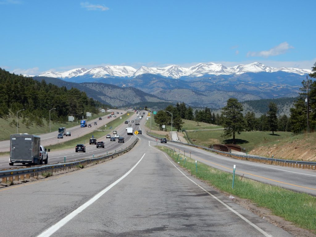
It only gets better from there.
I stayed on I70 up through the Eisenhower Tunnel and on to Frisco, which was the exit I needed to head south through Breckinridge. The views from the highway overlooking Frisco don’t exactly suck.


While I was working my way through the stop lights in Breckinridge, Margaritaville started playing on my iPhone. Breckinridge may not be a beach, but it does have some of the same seasonal tourist flavor, even if it turns the seasons upside down. <shrug> It seemed appropriate to me.
Heading south out of Breckinridge, you start up Hoosier Pass. This would be my highest altitude of the day at over 11,000 feet. I took a few quick photos from the pass.


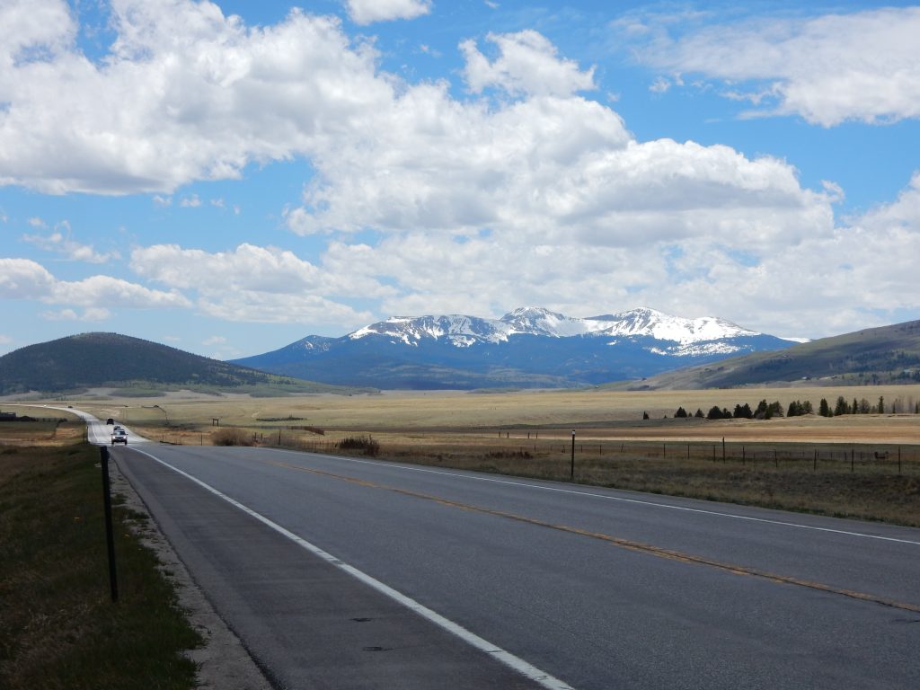
Continuing south, I eventually reached the overlook east of Buena Vista, where I would reconnect with my intended route (if I hadn’t elected to skip Leadville). There’s a nice little county park there that affords some excellent view of the Colleagiate mountain range.


After gassing up in Buena Vista, I continued south on US285, headed for Poncho Springs and a right turn on US50 west. This route takes you through a wide valley with the Collegiate to the west and lower mountains to the east. The road itself is fairly straight through the valley, so you can keep up a pretty good pace.
Video Capture
After turning west on US50, I stopped as I got close to the pass. I wanted to try capturing video with the iPhone. I have an app from the Hitcase makers that overlays Bike telemetry (speed, elevation, lean angle, Gs, etc.) over the captured video.
On the Nightowl, this means extracting my iPhone from the navigation cubby in the dash and mounting it with a Ram mount so it can see down the road. This was the first time I had tried to do this, so I didn’t know what to expect.
I captured video of my climb up the pass and the subsequent descent down the west side. Unfortunately, the mount isn’t stable enough and the camera bounces around quite a bit. You can make out what I’m doing, but I’m not posting it.
Blue Mesa
Riding through Gunnison, I thought about stopping for food, but it was already 3pm and I was only heading to Ridgway for the night, which was less than three hours away. I rode on.
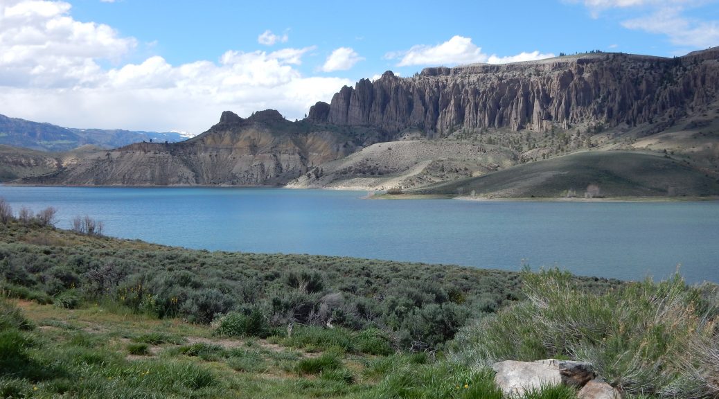
West of Gunnison is the Blue Mesa Resevoir, where the Gunnison river starts down into the Black Canyon, but is dammed up to create a nice recreational lake.
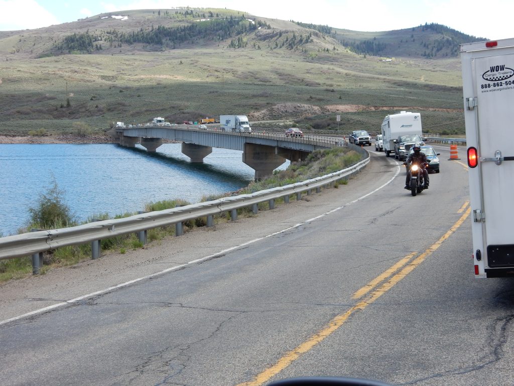
The bridge over the resevoir was under construction and down to one open lane, so I had to wait a while for my turn to cross the bridge.
Now on the south side of the lake, you get much better views of the spire-filled pallisades on the north side of the resevoir. I captured a few pictures and headed on.


I was becoming a little concerned about the clouds I saw coming over the top of the San Juan mountains to the southeast. That concern was keeping me from stopping for a few good shots, but my inner photographer got the better of me and I turned around to capture the views of the distant snow-capped peaks and a look down into the Black Canyon. You can decide if the turn around was worth the photos.


Weather Changes Everything
Once I got to Montrose, CO, I stopped to check weather. I could already see the clouds rolling over the tops of the mountains to the south (Sneffels being the most prominent) and I was wondering if Ridgway (my planned stop for the night) was going to get hit.
It turns out that Ridgway was expecting rain overnight but the low was only going to drop to about 38ºF so there shouldn’t be any snow.
However…
The pass I would have to ride through tomorrow morning was significantly higher in altitude and may be cold enough to drop some snow on that pass overnight. The other pass out of Ridgway was on US550 to the south, and Silverton (a town along that road) was expecting snow accumulation overnight.
Crap.
There was a good chance that I could be fine for the night, but would have no rideable pass the next day… unless I turned back north to Grand Junction and the interstate.
It was still only 5:30pm, so I would still have a few hours of sunlight. I decided to push past Ridgway and over the pass on CO62, turn west on CO145 through Norwood, and take CO141 south through Gypsum Gap and on to US491, which would take me west to Monticello, UT. That would get me past the weather front that was passing through and keep me from possibly getting left without a good route to take.
Wind, Rain, and Weather…
Hell bent for leather,
Wishin’ my gal was by my side.
Pardon me while I quote the theme to Rawhide.
The last136 miles of the day turned out to be a fairly epic ride. The weather was closing in, with leaden clouds pouring over the mountains just east of the pass I was traveling though, and I was trying to make time so I could get through the cold front before the precipitation it was dropping turned to snow.
The pass on CO62 (down towards Telluride) wasn’t that bad. It was mostly dry and the temperature didn’t drop low enough for snow to form. Once over the pass, you’re in a deep valley and sheltered from the winds by the cliffs and the surrounding forest.
At the intersection with CO141, a left would take me to Telluride. Half of the cars coming from that direction had snow at the edges of their windshields. Uh, I love Telluride, but not this time. Turning right takes you deeper down into a canyon floor, following a small river. Eventually, he canyon gets too narrow and you cross the river and climb he south wall to get back out of the canyon.
As I crested the edge of the canyon, the wind hit me and almost threw me back in. Based on cloud formations, the edge of the cold front was just off to my west. That’s where the low-hanging clouds stopped and a partly-cloudy sky was a tantalizing sight just past it. Below that last line of cloud was a broken curtain of rain. I say rain because the curtain had a grey hue, not a white one. Unfortunately, the border of the cold front was a bit chaotic in terms of the two air masses that were meeting here. The result was a wicked gusting wind out of the south.
I continued to fight my way through the wind until I reached the small town of Norwood. Below the Welcome to Norwood sign was a temporary banner that said Welcome Bikers but didn’t give a date or reason that bikers would frequent this location. I wondered if we’re missing a good party; that would be a shame.
Note: I looked it up later. That coming Friday was the start of a mountain biking jamboree. Oh well.
I stopped for gas in Norwood since my miles-to-empty gauge said 62 and I knew Monticello was further away than that.
Pulling out of Norwood, CO145 briefly turned north. It was as if I had entered a sensory-deprivation zone. The wind noise stopped, the bike stopped being pushed to the right and I had to dial back on the throttle to prevent accelleration to 90 mph. I guess that south wind was pretty strong.
A Road to Myself
West of Redvale, I turned south on CO141 to eventually pick US491, which would take me into Utah and on to Monticello. I’ve never been on this stretch of road and it turned out better than I expected.
The first reason is that after briefly dodging the curtain of rain that I had just fought through (the second dose wasn’t as bad), the sun actually peaked through the clouds a few times. The second reason is that the wind died down a bit, not much, but enough that I didn’t feel like I was fighting a hurricane to make the Nightowl move down the road.
After climbing a through Gypsum Pass, things improved even more. I was now getting more sun than clouds and the winds settled down to almost nothing except for the occassional gust. The road conditions aren’t the greatest on this road–the surface could use a refresh–but it was plenty passable and didn’t reduce my desired pace. The scenery was varied: high-desert sage fields broken by forests of pines and an occassional rock outcropping. Best of all, in the 54 miles that I traveled this road, I did not encounter another vehicle. Not one.
As I approached US491, the largely deserted landscape turned to farmland. Usually this wouldn’t be very interesting, but this is spring in Colorado, which means the deep green of the fields of winter wheat stand in start contrast to the orange-tinted earth in the freshly-turned fields. Add the reddish-orange lighting of the setting sun and it was lovely.
Room and Food
The home stretch into Monticello passed without incident, aside from the return of the nasty crosswinds and a deer that cut in front of the truck ahead of me. No Bambis were maimed.
Monticello is not that big a town. It’s only claim to fame is a nice little wind farm and its location at the south entrance to Canyonlands National Park. I drove to the north side of town and ask for available rooms and the big inn up there. I picked this one first since it was the only one with a hot tub and I was a little chilled. No vacancy.
I proceeded back down the main drag and picked out a nice little strip hotel, the Horsehead Inn, whose No Vacancy light was not lit. I secured a room, the last one at the far end of the strip (cool!), and received a recommendation for food at the Peacetree Cafe down the street.
I ordered an amber beer from a brewery up in Moab and a plate of Cajun pasta with shrimp. The small anteroom I was in was populated by four other solo diners. There was a young man in all black from Montreal, an older vagabond from Chicago who was traveling on his retirement checks, and a young hiker from Phoenix, AZ. The conversation was interesting; the food was excellent (don’t forget the brownie cheesecake dessert), and I was headed back to the room.
While the room was certainly nice–it was roomy and clean–the WiFi absolutely sucked sperm whale pecker. It was slow, made me reinitialize my connection constantly, and absolutely refused to let me upload images to the blog. I can certainly recommend the room but only if your stay has no requirements for an online connection.
Route and Altitude Maps
Here is today’s route map (with altitude overlay) and a separate map showing the altitude by itself.


…And For Tomorrow
I need to finish this trip report, perhaps at another provider of WiFi, and make my way across Utah, keeping a wary eye on yet another cold front that may rain/snow on my parade.
One thought on “Colorado Passes and Dodging Snow”