
I’ve accelerated my pace a bit to try and arrive a day early, so mountain passes, a nasty construction zone that closed US50, oppressive heat, and a steering instability issue with the Nightowl were not helping me get down the road.
Before the ride
My alarm was set to 8:30am, but I was already awake at 7:45am, so I got up and started pulling myself together. I spent a fair amount of time looking at the thread I started on the K1600forum.com site about the weird squirrelly center tracking behavior I was experiencing at mid-range speeds. The consensus was that it was either failing front wheel bearings or a worn out steering bushing or steering damper. Luckily, there was a bona-fide BMW motorcycle dealer in Grand Junction, Colorado, which is right on my way west today.
The other factor to figure out for today was the major construction project on US50 between Gunnison and Montrose, which was standing squarely in my path and drooling in anticipation of an opportunity to screw me over. There was an entire web site dedicated to the project to help the locals plan their days when they had to pass through the area. On your typical weekday (like today), there were three (3) windows where the road was open for one-way-at-a-time traffic. Basically, they’d let traffic go west for about 20 minutes and then wait for those cars to clear the construction zone. Then they’d let traffic go east for another 20 minutes, wait for them to clear, and close the zone back down.
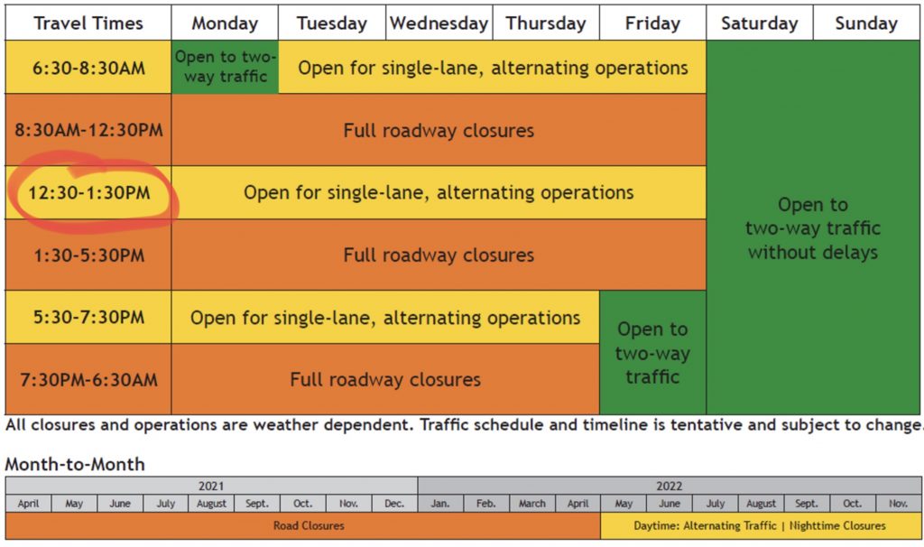
The early window was just too damn early for me to get up and ride the two hours to get there in time. The late-afternoon window was too late to do me any good; I’d basically be waiting in mid-Colorado all day. The only window that would work was the 12:30-1:30pm window.
Naturally, I this was the most popular option for everybody, so a queue started forming at about 11:30am of people waiting to get through. If the queue was long enough that you didn’t get past the entry point within 20 minutes of opening the zone, too bad. You get to wait for the next window.
The only other way around this was to take a detour on Colorado route 92, which was longer, slower, and more of a technical challenge, especially for those poor bastards with huge motor homes or travel trailers. Still, I’d traveled that route before and it did provide some lovely scenery; if you have to take a detour, you might as well enjoy it.
I decided that I would play it this way:
- Get an earlier start (really, I mean it).
- Get to the construction zone and check out the queue.
- If the queue looks favorable, hang out until the 12:30 window.
- If the queue is a clusterfuck, or I get there earlier than expected, take the detour.
The only thing left to do was shower, pack, and call Grand Junction BMW (actually, Grand Junction BMW, and Harley, and KTM, but who’s counting?) to apprise them of my situation and to expect me to make an appearance. The dealer didn’t open until 9am, so I got the other morning obligations out the way first.
A quick check of the weather didn’t provide any dramatic revelations. It would be sunny, hot, and not overly humid. The ride through most of Colorado should be tolerable, but temperatures west of Grand Junction would be flirting with triple-digit values (100ºF/38ºC).
With the body cleaned and the Bike packed, I called the dealer and got an answer machine for their service department. This does not instill confidence, but what’s my alternative? Some of my biker friends are/were service writers, and they crave detail almost as much as I do, so I left a full minute of details on what I was experiencing and what I thought might be the source of the problem. I ended with my wild-assed-guess at an arrival time and my cell phone number. With the ball in their court, I exited my hotel room, threw a leg over the Nightowl, and pointed the handlebars west. It was 9:12am.
Chapter 1: The ride through Colorado
Salida is conveniently located a few miles away from US285, which is the main north/south highway that traverses the valley just east of one of the primary Rocky Mountain ranges in Colorado. That was good news for me because it meant I’d be riding US50 over Monarch Pass within the first 30 minutes of today’s ride.
For me, Monarch Pass is a perfect appetizer for mountain riding. It’s not overwhelmingly twisty, the road is in great shape, and it’s popular enough (there is a ski resort at the top) that it has passing lanes almost all the way up. For a Midwesterner like me, who can’t ride all year and doesn’t exactly have 10,000+ feet (3,000+ meter) mountain passes in his back yard (or state, or time zone), this is a great way to reacquaint yourself with, well, how to enjoy a mountain road without killing yourself in the process.
Aside: Don’t get me started about the idiots that take their motorcycle out of the garage/shed/barn for the first time in a given riding season and immediately seek out the most challenging road they can find. I once traveled the tail of The Dragon early in the season and encountered no less than three (3) morons who had found the ditch that day… all in one 11 mile stretch of road.
Traffic was fairly light, so I made surprisingly good time up Monarch Pass. The trip down the western slope, however, was complicated by a few construction zones that stopped traffic at one-lane zones. This meant that, on multiple occasions, I got stuck in a line of cars all moving away from a construction zone. Luckily, I have a veritable rocket sled of a motorcycle and, if the mood struck me, which it often did, I could work my way through the line of cars and into the clear.
The western slope of Monarch Pass doesn’t drop you back to the elevation where you started. The central Colorado region, centered on the town of Gunnison, starts at 7,000 ft (2,100 m) and goes up from there. Consequently, the temperature in this region was quite pleasant. I even had to zip up my sleeve zippers to stave off the chill.
This higher-altitude region also looked like it had been getting plenty of rain. The pastures were green, the rivers and creeks all had water running in them, and the ubiquitous scrub sage brush looked a little less pale green than usual. US50 wove it’s way between forested mountain sides, standalone mesas, and the odd canyon cut. The sky was clear, the air light and crisp, and the greens of the land and blue of the sky was nicely accented by the snow-capped peaks of the San Juan mountains off on the southwest horizon.
This is why I drag myself out here.
Even with the construction zones, I made good time to Gunnison. Since I was nowhere near short of gas, and the lack of oppressive heat meant I still had plenty of water on board, I rolled right through downtown and continued west towards the impending construction doom I’d been reading about.
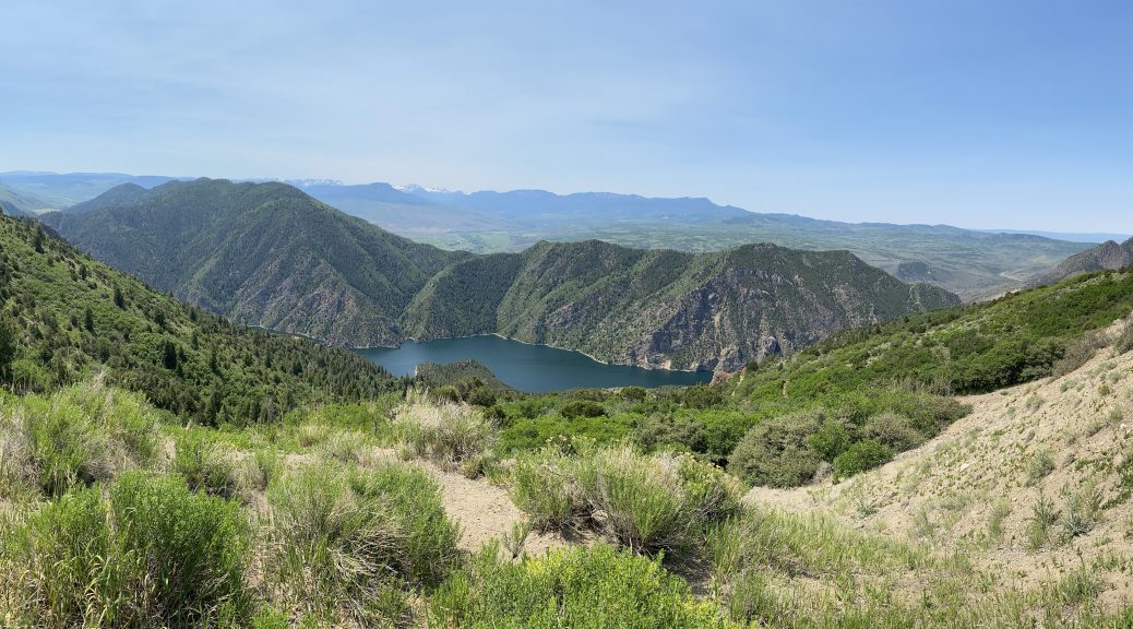
I rode along the shore of the Blue Mesa reservoir and noted that I’ve never seen the water this low. (For some photos of the area, see this post.) It’s still impressive, but it felt weird to see cars parked near the current coastline that I would have expected to be under several stories of water.
Towards the west edge of the reservoir, near the dam that impounds it, was the flagman that was the master of the dreaded construction zone. I’d made great time and it was just a little after 11am. It was the flagman’s duty to tell the drives what their options were, which consisted of:
- Pull into the adjacent parking area and wait until patiently for ~90 minutes until the traffic window opened… and that assumed that they ran the traffic westbound first, otherwise you had an even longer wait.
- Drive on another mile (1.6km) and turn off before the construction death zone and onto Colorado route 92, which was the longer, more challenging, alternative route.
- Turn around, go back to Gunnison, and ponder your sin of not checking into this sooner (it’s not like there weren’t 10 gazillion signs warning motorists that this was coming).
Give my earlier-than-expected arrival, I was not about to sit around in the sun and cook for 90 minutes (or longer) waiting to get through. I was committed to staying on US50 as a part of the Redbeard commemoration thing, but time siting here was time that could be spent fixing the Nightowl’s nebulous suspension issue in Grand Junction.
Decisions…
Then I jokingly thought to myself: What would Redbeard do?
Sit and wait, or divert to a curvy, mountainous road that passed along a canyon so gorgeous that it was eventually turned into a National Monument (Black Canyon of the Gunnison).
Upon reflection, it was an extraordinarily stupid question.
When it was my turn to plead my case at the flagman, I simply said, “I’m here to ride route 92.” He looked over the Nightowl, smiled, gesticulated dramatically down the road, and said, “You go right on ahead.”
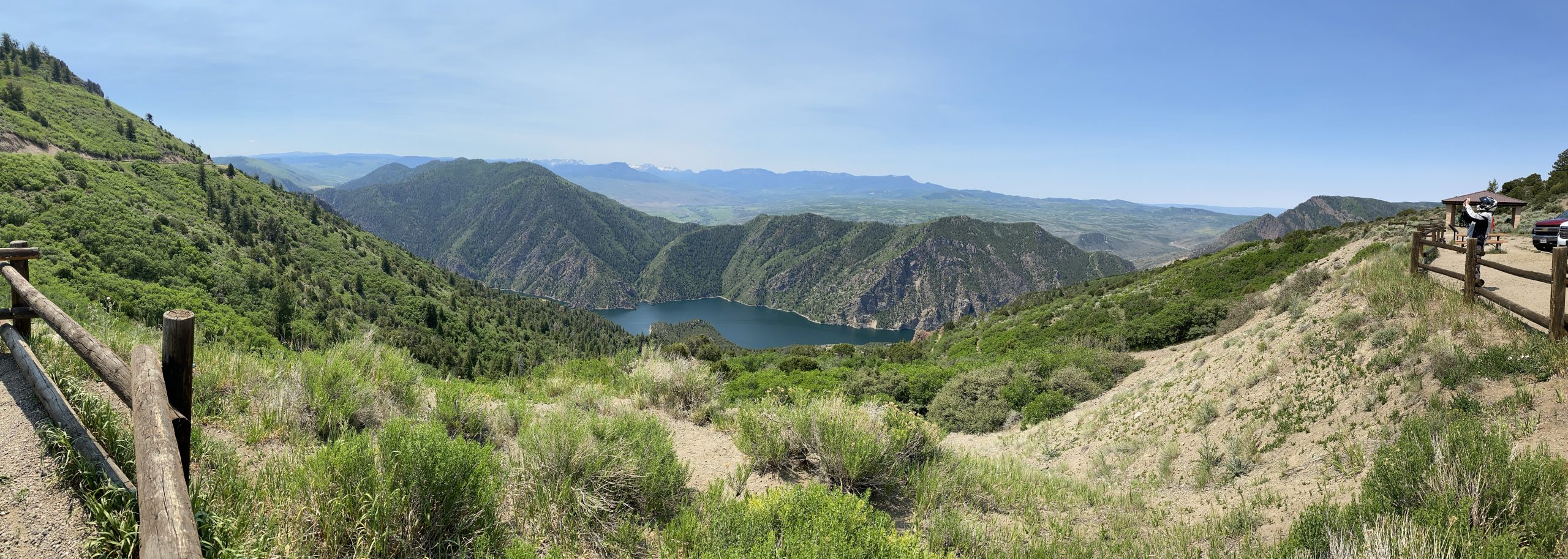
After crossing the dam to the north side of the Gunnison River, CO92 weaves along the deep canyon wall, all the while increasing in altitude. This makes for some dramatic views since the north rim of the canyon is significantly higher than the south rim. In addition to seeing down into the canyon itself, you’ve can easily make out the San Juan peaks to the south (especially on a low-humidity day like this one).
The last time I rode CO92, I took my time and snapped dozens of photos. Given my time constraint and desired to get to the dealer, I only stopped once. Nearly everybody stopped at this overlook, so I had a chance to chat with a herd of four fellow bikers (all on different disparate brands of bikes), a few tourist families, and one family-reunion-sized bunch of folks that looked like a clown car when they piled out of a huge Class A RV that was towing a travel trailer. I had to wonder if the parents stayed in the motor home and the kids slept in the extra apartment they were pulling. Wild.
A panoramic photo of the Black Canyon of the Gunnison. 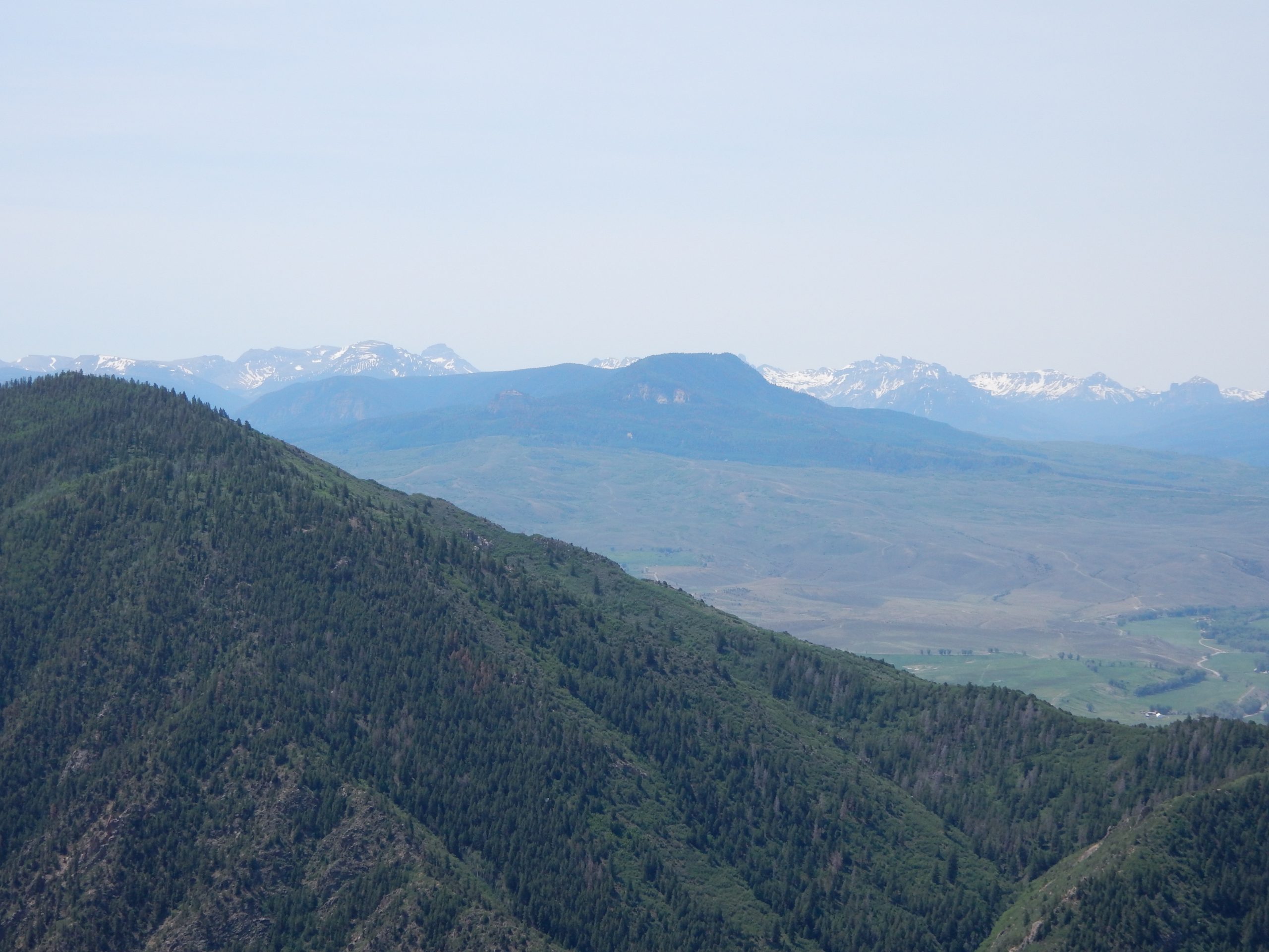
The San Juan mountains as seen from an overlook at Black Canyon of the Gunnison. 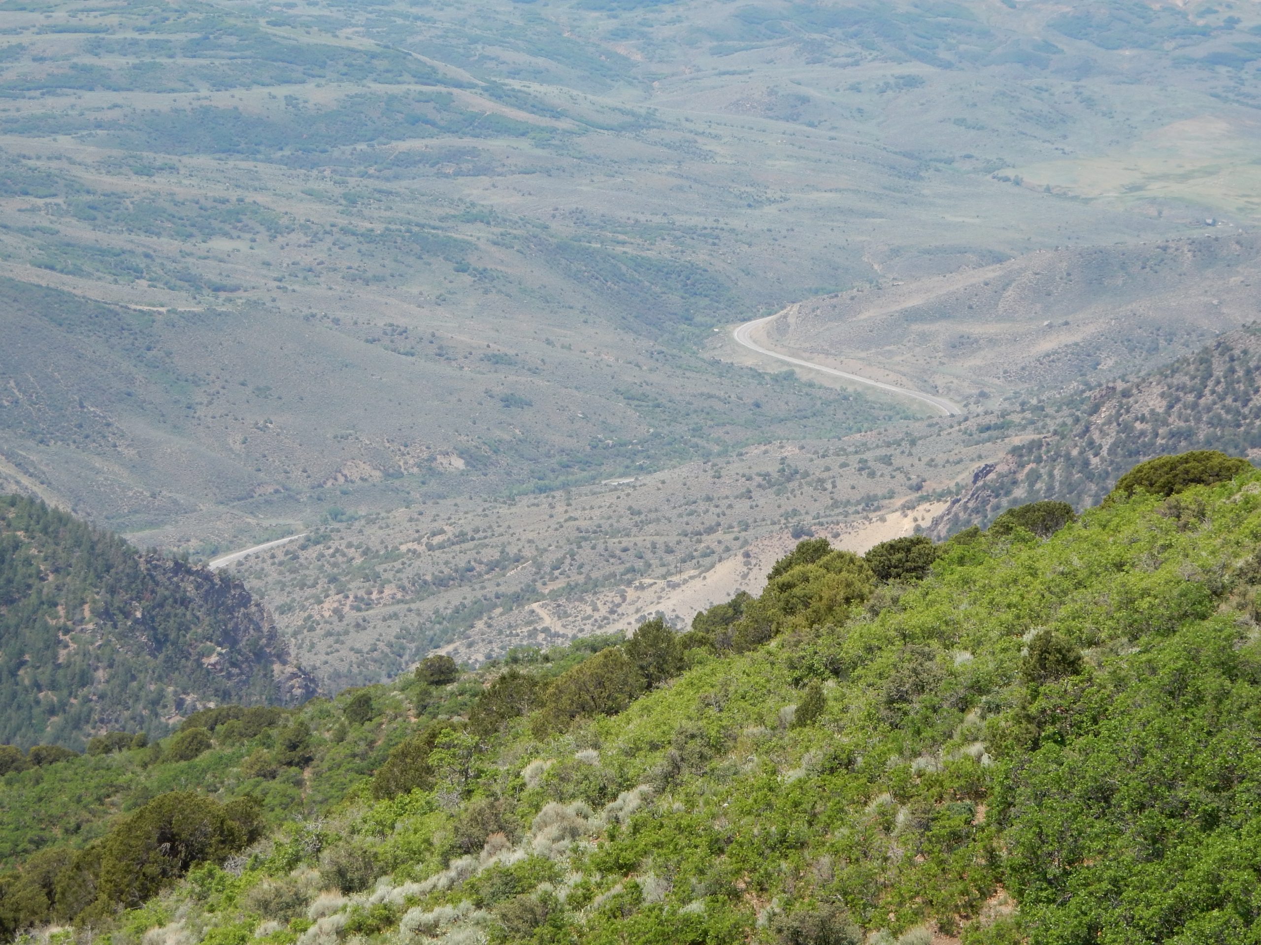
An empty stretch of US50, as seen from an overlook at the Black Canyon of the Gunnison.
A bit west of that overlook, CO92 turned north away from the canyon and made it’s way to lower altitudes. In other words, it started getting hot… really hot. When I eventually turned west towards Delta, Colorado, I read this trip’s first triple-digit temperature.
But wait… it eventually gets worse.
At Delta, Colorado, I rejoined US50 and continued northwest towards Grand Junction. I was pleased that the US50 construction at Blue Mesa hadn’t had much of an impact on the day. Cool.
What wasn’t cool was the closer I got to Grand Junction, the hotter it got. I’d been through Grand Junction before and knew is was basically a desert climate there, so this was expected.
What I didn’t precisely remember is where the BMW motorcycle dealer was in Grand Junction. I just remembered that I had scene it from I70. US50 would eventually join I70, but I was sure that was a good piece west of where the dealer was, and I didn’t want to backtrack. I pulled into the shade of a gas station canopy and did a quick lookup of the dealer on my phone. Sure enough, it was almost directly north of my position; it was good that I didn’t ride any further northwest.
Fifteen minutes later, I’d parked the Nightowl and was walking into the service department at Grand Junction BMW/Harley/KTM.
Chapter 2: The dealer visit
I was only standing for a few minutes before one of the service writers was free and called me over. John was the voice on the automated attendant for the voicemail I’d left this morning. I did a quick summary of my situation and his eyes lit up and he produced a pad of paper with a bunch of notes from the 18 messages waiting for him this morning when he got in.
Yeesh.
I saw that he’d written down all the gory details from my voicemail message, so I dove right in with the current condition and the possible diagnoses I’d collected from the K1600Forums.
We agreed that front wheel bearings were a definite possibility, but his opinion was that if I’d installed them poorly enough that they failed early, they probably would have failed during the last trip out to California and back. We also talked about the front wheel being out of balance, but I ensured John that I wasn’t feeling a pulse or vibration, which would be common for an imbalance issue. We then considered front suspension problems.
John said they were slammed and couldn’t get to it for a day or two and they would likely have to order the parts if it was something other than wheel bearings.
Bummer.
Then we went out to the Nightowl to see if he noticed anything obvious. The tire looked good. There wasn’t any alarming wiggle when he held the front tire and I tried to turn the handlebars. Then we put more force on the handlebars and the front end let out a definite metallic “clink” coinciding with a tactile movement in the handlebars. We both made “Well that ain’t right” exclamations and started looking more closely at the front wheel and suspension components.
Suddenly, John let out a whoop like a hound dog finding a bone. He called me to the front of the bike and showed me the culprit.
The right-side axle pinch bolt was loose, not even finger tight.
Good… God… Almighty!
We have found the enemy, and it’s me. I distinctly remember tightening the pinch bolt during the last tire change (just before this trip), but I must have fubar’d the torque spec and left it too loose.
I thanked John enthusiastically for his input and let him get back to his overwhelming backlog. He seemed genuinely tickled that we’d found the root cause of so perplexing a set of symptoms.
I found some shade in a nearby parking lot (it’s 105°F for shit’s sake), dug out the tools, and tightened up the offending pinch bolt. A quick test ride of figure eights in the parking lot revealed a marked improvement in low-speed stability, with none of the can’t-find-center squirellyness that was present before. Now the Nightowl was rock solid.
Let’s all spend a moment to tip our caps to John Barker at Grand Junction BMW, a man who is kicking maximum ass in customer service.
It was now 2pm and I’d yet to consume anything other than water. I scoped out a few nearby lunch candidates with the Yelp app. I decide to try Bistro 743, but when I drove to it I discovered that it was the restaurant inside a hotel/convention center. Probably not the quickest solution. My backup was just a few blocks further down the street, a Mexican joint called Azteca. They didn’t have any shaded areas in their parking lot, but there was some shade in the landscaping between parking lots. Once again, creative parking strategies ensure that the ride will not continue on a saddle as hot as a frying pan.
For lunch, I obtained a carne asada burrito, Spanish rice and retried beans. It was tasty, served lightning quick, and accompanied with plenty of ice water. My waitress (actually, the only waitress) ferried extra glasses of water at the end so I could fill my on-the-bike Camelback for the road.
Chapter 3: The ride across Utah
Between Grand Junction, Colorado and the mountain range just east of the path of I15 in Utah is a stretch of desert I can only describe as magnificent desolation, which happens to be how US astronaut Buzz Aldrin once described the surface of the Moon. This region is nearly 200 miles wide, deserted except for a few isolated towns, and often hotter than hell itself.
One famous idiosyncrasy of the piece of I70/US50 that traverses this wasteland is the lack of any kind of travel-related services (water, gas station, rest room, etc.) for 106 miles (170 km).
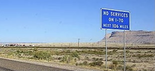
There are actually two of these long segments utterly devoid of support for the wayward traveler. The first one is a mere 60 miles (96 km), and that ends at an exit that literally has nothing on it but a gas station. The longer segment, between Green River and Salina, is the granddaddy that everybody remembers.
My preparation for making this crossing is to make sure I have a full Camelback of cold water and a full tank of gas (or at least a 50% safety margin of range in the tank). My current range reading meant that the Nightowl could easily reach Salina on the gas in the tank. I was not as confident that I, or my on-board water, would last the entire distance.
The first segment from Grand Junction to Green River was, in a word, miserable. The highest temperature I read was 107º F (41.7º C). Combining the heat with the high rate of travel — speed limits are often allowed to be higher in desolate regions — made it feel like I was riding into a blast furnace. I’d been trying to save my on-board water, but it was heating up so fast, I was trying to drink it all before it was hot like a cup of coffee or tea.
When I reached Green River, Utah, I exited just to replenish my on-board water, and rehydrate myself a bit too. Now becoming my go-to combination for afternoon relieve-the-heat stops, I quickly drained a bottle of Vitamin Water and savored the chill of a strawberry shortcake ice cream bar (there are worse vices to have). I also got permission to fill my Camelback with ice and water from the convenience store soda fountain; since I already purchased something, most establishments are ok with me doing this.
Back out at the bike, I spotted an outdoor hose spigot and decided to engage in a heat-control strategy I haven’t had to use since my friend Chuck and I rode across eastern Washington state on an especially sweltering day. I removed my t-shirt, drenched it to the saturation point under the hose spigot, and put it back on (ooooh, chilly). I then put my leather jacket back on over the dripping t-shirt, hopped on the Nightowl, and set of to conquer the 106 miles (170 km) to the next services at Salina, Utah.
West of Green River, I70 crosses the Waterpocket Fold, a geologic formation that separates the lower desert pan from a higher elevation desert steppe. Within about six miles (10 km), the landscape rises a couple thousand feet and the changes are readily apparent. The temperature drops and you start to see bushes and trees again. If there’s any humidity in the air, it tends to form a haze, which helps to filter the sun’s harsh rays. The sum result is that the ride got a lot more comfortable. This high desert steppe lasts almost all the way to Salina, where you drop into a valley, but not so far down that you’re back in the desert pan.
Exiting in Salina, Utah, I filled up the Nightowl and replenished my on-board water supply. My t-shirt was nearly dry except for the small of my back and around the belt line (my t-shirt had been tucked in). Since it was only in the mid 90ºs F (34º C), I refrained from soaking my t-shirt a second time.
Between Salina and Delta (both in Utah), US50 jogs north from I70 to another interstate highway, I15. It travels along a valley floor between two low mountain ridges, both of them unbroken with no paved roads crossing them. This valley gets more precipitation than much of the surrounding area and is quite a bit greener. Lots of ranch land with livestock wandering the fields. Most travelers don’t take this shortcut in favor of following I70 all the way to I15 and then turning north. This makes the valley segment sparsely traveled, making for a nice laid-back ride, both technically and visually.
After you intersect I15, you double back south for a short stretch (less than 10 miles (16 km) and then continue on two lanes north and west to Delta, Utah. I arrived at about 7:30pm.
I’ve stayed in Delta before and usually get a room in a run-down little strip motel called the Delta Inn. They’re cheap and fall into that “Notch Above Scuzzy” (NAS) category. They do not, however, take online reservations. The Budget Motel, however, does take online reservations through hotels.com, so that’s were I unpacked for the night.
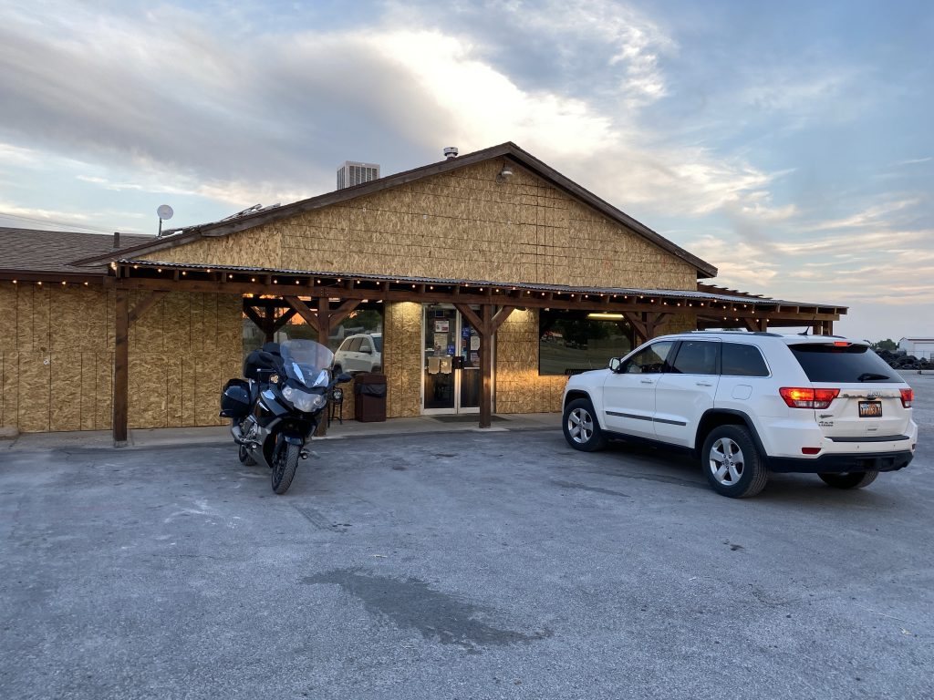
Now I needed dinner, and nearing 8pm in a little town on a weeknight meant my options would rapidly be depleted. Luckily, Ashton’s Burgers is open until 9pm. While it’s very common for a local establishment to serve both as a bar and a grill, Ashton’s is a bit unusual since it is a butcher shop and a grill. The butcher shop side sported freshly cut pieces of beef, chicken, and pork. Curiously, these were the three main meat offerings at the grill.
I opted for a grilled chicken sandwich with bacon and cheese, with a side of onion rings. I was the only customer in the place at this time of night, so the food arrived quickly. Very tasty.
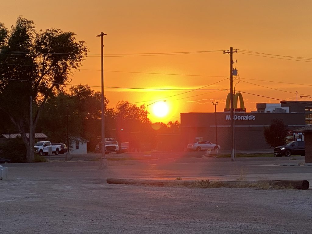
I managed to get back to the room with my to-go drink balanced between my legs, just in time to catch the sunset.
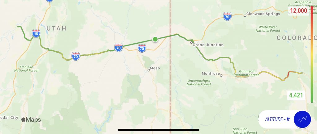
Map
Today’s map shows a straight jump from around Grand Junction all the way to Green River. This is where my iPhone shut down some functions because it was overheating.
Video
The evening was getting late, so I didn’t do much tuning of these scenes for brevity; that’s why it’s so long. If you watch it in YouTube, you can use the the provided chapters to jump around in it.
I’m also trying to master the art of wiping off the front camera lens during every stop.
Tomorrow
Crossing Nevada on US50 is like using shampoo. Instead of “lather, rinse, repeat” you have “desert pan, mountain pass, repeat”. If I get to Carson City, Nevada or South Lake Tahoe, California, I’ll have a very easy day on Thursday to get to the party location.
Geeky tidbits
Putting my iPhone in the GPS cubby hold in the K1600 dash means it doesn’t get a lot of ventilation and can overheat on hot days. It doesn’t help that I’m running several communication-intensive and/or GPS-leveraging apps at the same time:
- Waze app for on-the-fly navigation with crowd-sourced condition updates.
- Trails for logging my GPS track over the course of the day. This is what creates my map graphics. I assemble all the tracks after the trip and post a interactive Google Map of the entire trip.
- FollowMee for logging my position every 10 minutes and sharing it on the Where is Ghost page (email me for the password if you want it).
In addition, when I’m listening to music, I often stream it from the iPhone, which is over Bluetooth.
Finally, the iPhone is plugged in for live charging. Given all the GPS activity, the charging rate tends to be fairly high, which means additional heat being generated by the battery.
All these factors, including today’s 100+º temperatures, finally made my iPhone 11 Pro shut down. It’s nice that it does it in stages, but it should really use the high-capacity as one of the dominoes to fall before it starts shutting off features like GPS use. I would rather have had the iPhone keep the GPS track alive and allow the battery to slowly discharge (charging at a lower rate) until the battery level got, say, to 10% capacity. Instead, it constantly tried to fast-charge the phone from it’s state of 47%, which started the domino effect of lost functionality within a minute of plugging it into power. First the backlight dropped to zero, then the GPS functions ceased, then the Bluetooth radio shut down. I like this domino effect of higher impact as the heat becomes a bigger problem, I just think the fast-charging should have been one of those dominos, falling back to a lower charge rate.
Here endeth your geeky diatribe of the day.