
The last day of this trip. All I have to do is dodge a few rainclouds between Des Moines, Iowa and Ann Arbor, Michigan. What could go wrong?
Before the ride
For reasons I cannot explain, I woke up before my 8:30am alarm, again. A quick look outside revealed a wet landscape, but no rain was actively falling; it must have rained earlier.
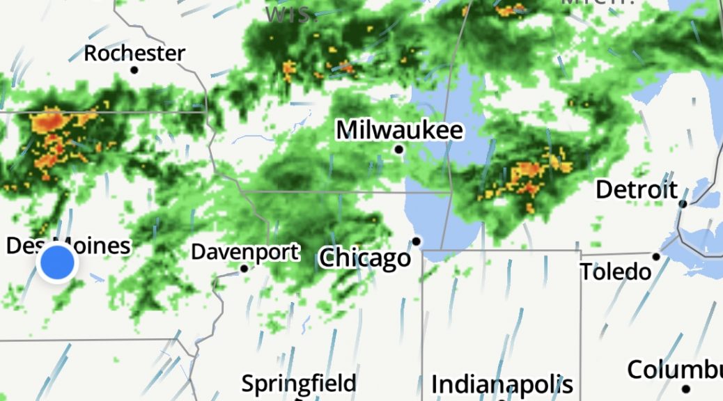
I checked weather and looked at the radar image between Des Moines and Ann Arbor. There was an obvious frontal boundary that was passing between the two cities. It had passed Des Moines overnight. It wouldn’t not reach Ann Arbor until early Sunday Morning (today was Saturday). In short, I would have to ride through it.
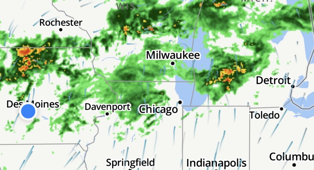
A look at the radar estimates for the next six hours showed the frontal boundary, not obvious in the image above, blossoming as a line of ugly red as the day transpired, There may be a break in the line of storms near Chicago by the time I get there, again, if I’m extraordinarily lucky.
Down on the Nightowl, I dug out my rain gear and verified that everything was in order. I had a strong suspicion that is would be called upon today.
Like nearly all the motels that I’d stayed in during this trip, this one wasn’t serving it’s usual breakfast because that wouldn’t meet the remaining COVID-19 protocols. That’s fine, I’d eaten well, and late, the evening before.
If I had any hope of spending a nice night out on the town reuniting with my wife, I’d better get down the road. I knew I would be crossing a single toll booth south of Chicago, so I pulled out my EZ-Pass transponder and installed it on it’s two tabs of 3M DualLock towards the bottom of the windshield.
The dry half of the ride
The highway’s through Des Moines were still a little wet, but only enough to throw up a minor amount of road spray; no need for the rain gear yet.
Aside from a few truck races, where left-lane truck passes right-lane truck at a pace of right-lane truck speed + 0.001 MPH, I made good progress. It was still a bit cool, so I had the jacket’s vents closed and my sleeves zipped up.
Along about Iowa City, I caught the tail end of a raincloud moving across my path to the northeast. Again, as long as I was moving at highway speeds, the Nightowl’s fairing and windshield would keep me surprisingly dry.
The miles rolled.
There was some construction around Davenport, Iowa and across the bridge into Illinois, but nothing that delayed me more than a few minutes.
Shortly after Davenport, I begin to see patches of blue sky between the cloud cover. I was still wearing my normal glasses, so I lowered the Shoei Neotec’s sun screen so I wouldn’t have to stop and get out the sunglasses.
I needed to stop for gas and a bathroom break as I approached the I57 interchange and the aforementioned toll booth. I stopped in Joliet, gassed up the Nightowl, used the convenience store facilities, and grabbed myself a road lunch of Vitamin water and a package of Cherry Pop-Tarts. As I ate, I looked at the partly sunny surroundings and the slightly darker clouds to the south. To the east, the skies didn’t look threatening at all. It was just possible that I’d broken through that frontal boundary in a weak spot.
The drowned rat half of the ride
Boy was I wrong.
Having not consulted an actual compass, I was unaware that the darker clouds to the south were actually south-east of me and high-tailing it to the northeast doing it’s best to beat me to the strip of I80 and I94 that I needed to traverse.
I hopped on the Nightowl, and headed east.
As I approached the I80/I57 interchange, I could see that the dark clouds did indeed extend north of my path on I80. I was still confident that it would be OK since the veil of rain falling from that cloud formation was falling well to the south of me.
My pace was still good, in spite of the increased congestion as I neared Chicago. As long as I can keep this up, I should be able to get in front of this.
As I neared the I294 interchange, the one four-mile (6.4 km) stretch of road that was a toll road and demanded $1.50 for you to pass, I saw something I’ve never seen before. I’ve one of the orchestrated fountains in Las Vegas, but upside down, the veil of rain in the dark clouds suddenly started extending north; a diagonal veil of rain that fell from the sky, directly across my path barely a 1/4 mile (0.3 km) in front of me. The one difference between this curtain of rain was that I couldn’t see through it at all; it was like I was driving into a wall of grey mist.
Within seconds, brake lights came on for every vehicle on the highway. For a brief moment, I considered pulling to the side to put on rain gear, but I was near the end fo the I294/I80 interchange and I had three lanes of traffic and another two lanes of on-ramp to traverse if I wanted to get to the right shoulder. This squall had appeared so quickly, I figured that I’d pop out the other side of it soon enough, as long as I could keep moving.
The rain was now accompanied by a howling wind. At first I thought it was the wind that was making the rain sting as it the exposed flesh of my neck between the helmet and my jacket collar. Then I noticed that some of the rain was bouncing when it struck vehicles and the road service.
It was hailing.
Thankfully, the hail stones were small and they didn’t turn the highway into a floor of marbles, but it did slow everybody down even further, so slow for the Nightowl’s fairing and windshield to protect me at all.
Visibility dropped to only about 100 feet (30 m) and I lowered the windshield so I could see over it unobstructed.
The conditions got a lot worse as the highway crossed the Thornton Quarry. The quarry was a mile wide and nearly 400ft (130 m) deep and the highway crossed it on a thin ithsmus of land left by the quarry diggers with a bridge in the middle so equipment could cross from the quarry north of the highway to the rest of the quarry south of the highway. From an atmospheric perspective, it was like the highway was suddenly 400 feet in the air on a bridge with the wind whipping around it. I saw a few tractor trailers with their trailers crabbed out to the side several feet due to this crosswind.
Just east of the quarry is the interchange between I94 and I80 (this is where the I294 toll road ends). The highway there gains a couple of lanes and I was hoping that it would let me move a little faster and (hopefully) get in front of this maelstrom.
That’s about the time all the brake lights came back on and traffic ground to a sudden halt.
Side note about iPhone navigation
I was using the Waze app on my iPhone for navigation. This is a cheaper alternative than the BMW Nav units (currently at Nav VI as of this writing) that often sell for over $800. One downside to the iPhone being out in the open (at least it’s screen is exposed) during the rain is that the screen often registers the raindrops as taps on the screen. I didn’t know it at the time, but the deluge I was riding through had successfully tapped the screen to instruct Waze to:
- Stop the current route home.
- Start a new route to my work place.
- Turn on integration with Facebook.
- Accept the invitation to create a new Facebook account.
Since the iPhone screen is slightly larger than the hole in the dash for the BMW Nav units, a button in any extreme corner is out of reach. Consequently, I couldn’t see what Waze wanted me to do because the user interface was stuck at a full-screen dialog box prompting me for the first and last name I wanted to use with the new Facebook account it thought I wanted to create.
Merde.
What I could do, however, it hear the voice prompts from Waze, and suddenly Waze was telling me to exit the highway to the south.
You’ll get no argument from me.
My detour around the I94 closure
I found a few gaps in the rapidly congealing traffic and escaped onto the right shoulder for 100 yards (100 m) to get clear of the mess and escape the very wet parking lot that the highway was becoming. I found myself traveling south on Illinois highway 394.
At the first exit, Waze instructed me to, basically, do a U-turn. That’s nuts. It’s taking me right back into the disaster up on the highway.
But no…
Waze had me turn east on a side street and follow it for several miles, paralleling I94 to the north.
During this side-street traversal, the rain slowed and then stopped completely. There were some clumps of hailstones in the gutters, but otherwise the roads were in good shape. Perhaps that was the frontal boundary crossing I was concerned about. If it could get back to I94 and put some distance between me and the storm, I’d be rid of it.
During a wait at a stoplight, I got an alert from the iExit app that I94 was closed in both directions at the I294 interchange. Apparently, whatever happened there was very bad indeed.
The final stretch
Now back on I94, it was a bit like riding through a post apocalyptic movie. There were leaves and downed limbs on the roadway. There were large puddles in the far left lane up against the K-rail that separated the east and west traffic. The westbound traffic was still moving and when they hit their own versions of the same puddles, a cascade of water came over the K-rail and drenched whatever vehicle was in the left lane.
Most of all, the weird vibe was caused by the lack of traffic on this exceedingly busy stretch of highway. With the closure only a few miles behind me, there were only a few places where traffic could get on I94 east. As a result, I made surprisingly good time trying to get away from the storm.
The rain was now completely stopped and most of the road spray was gone by the time I reached Michigan City, but it got worse again near the Indiana/Michigan border as the roads were saturated again from recent rainfall.
Usually, I would use voice commands to my iPhone to switch between a live radar image and my Waze navigation, but the funky state that Waze in (still that damned Facebook account creation) meant it wasn’t listening to commands. I had no ideas was was waiting for me ahead.
At the Michigan state line, I94 turns from east to north-northeast to follow the coastline of Lake Michigan as far as Benton Harbor/St. Joseph, where it turns east again. I wasn’t wildly enthusiastic about doing anything but travel east away from this storm as quickly as possible, but the only option for that was the I80/I90 toll road. I figured that the north-northeast track wouldn’t let the storm catch me; just parallel me, so I was probably OK and would pop out of this drenched shit storm sometime soon.
Nope.
The rain started again, lightly, when I reached Benton Harbor/St. Joseph. It wasn’t that bad, but it saturated the roads again, which meant blankets of road spray being thrown out by every tractor trailer or any pickup/SUV with off road tires.
I could have added my rain gear when I was on the side street back south of Chicago, but putting on rain gear over soaked Leathers is definitely closing the barn door after the horse has escaped. I knew I’d break out of this rain eventually, so I stuck with it.
Nearing Kalamazoo, the heavens opened with a vengeance. The cloud cover was dark enough that it became impossible to see those few cars that weren’t running with their headlights on. I started to see the occasional car off the road in the ditch, or tangled up with a guard rail.
This is getting really shitty.
About then, I head a weather alarm in my headset (I guess the Sena 20S Evo hadn’t become waterlogged yet) and an alert appeared on my screen announcing a Tornado Warning for the Kalamazoo area.
Great. Like I really needed another challenge added to this day.
About the time I reached the Galesburg exit, the rain slowed down to a sprinkle (still plenty of road spray) and the skies were visibly light to the east. Surely, I must be breaking out of these soggy conditions. I could feel, even through my soaked leathers, that the temperature was significantly higher and the humidity level was higher too. I guess the end of the frontal boundary wasn’t back in Chicago, but here in the storm I passed through in Kalamazoo.
On top of everything else, I really needed a bathroom. Perhaps it was the subliminal message in all this rain falling, or the stress of the day’s ride, or the fact that I was getting rather chilled in my soaked clothing, but I needed a restroom.
Ask and ye shall receive…
The motorcycle gods responded with a Rest Area at mile marker 97 and I pulled off confident that I could take care of business and get back on the road before that damn storm caught back up with me.
Wrong.
When I got out of the restroom and looked out the front windows of the building, heavy rain was falling.
Really?
I didn’t even care. I didn’t hesitate for a second. I pushed past the people huddled around the door, worried that they may get wet walking 100 feet (30 m) back to their parked car, and stepped out into the deluge. I got back on the Nightowl, fired her up, and pointed the handlebars east, muttering obscenities the entire way.
It only took me another seven miles to break out of the heavy rain at the I69 interchange. The rain stopped a few miles later near Marshall, and by the time I passed Albion, the rain was stopped and there was only road spray to contend with.
When I reached Jackson, the roads were just damp, not soaked, and I began to see patches of blue sky between the passing clouds.
Arrival
The last 40 miles (64 km) were, thankfully, uneventful. I even had to lower my helmet’s sun shield when the sunnier stretches got too bright for my normal glasses.
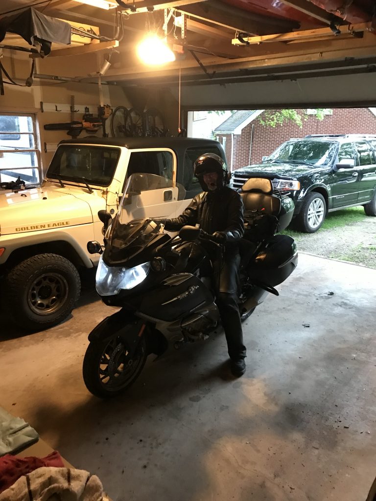
I pulled in to my garage a little before 7:30pm eastern time. Karen caught my arrival, but the photo doesn’t capture the fact that my clothing is carrying an extra 50 lbs of water.
When I unzipped my sleeves to take off my gloves, streams of water flowed out of my sleeves and onto the floor. When I took off my gloves, I was able to gently wring them out, leaving black puddles on the garage floor. All that black dye in the gloves had also stained my hands black (but only on the inside, against the grips). I hung up my jacket in the garage to drip dry and laid out my waterlogged chaps (boy, did they look clean) on the hood of the Karen’s Jeep.
When I took off my boots, I found that my socks were completely dry. I knew my boots were supposed to be waterproof; I guess they really are. In retrospect, I would have been even more miserable if my feet had been soaking wet too; I just didn’t notice during the ride that they were still dry.
I try to keep this blog between a PG and R rating, but in truth, I stripped down in the garage and proceeded straight to the master bathroom to take a hot shower and warm up.
Map
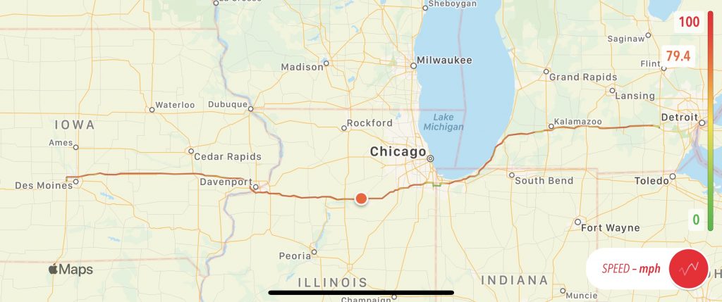
Today’s map has a speed overlay, showing where the weather slowdowns occurred. The short jog to the south below Chicago is where I made that just-in-time detour around a soon-to-be-closed I94.
Epilog
Karen and I did go out that evening. We enjoyed a nice dinner at the Common Grill (I was thrilled to get in without a reservation), and subsequently visited a couple of our favorite bars for a drink or two.
During our conversation, I could remember no less than five accidents that I actually saw (not including whatever closed I94 south of Chicago). This was a truly messy travel day and I was glad to have gotten through it without mishap.
In the next day or two, I’ll post a summary of the trip with links to all the days, an interactive map of (most) of the route, and some fun stats (for me) for the trip.
Until then, thank you for joining me on this journey.